|
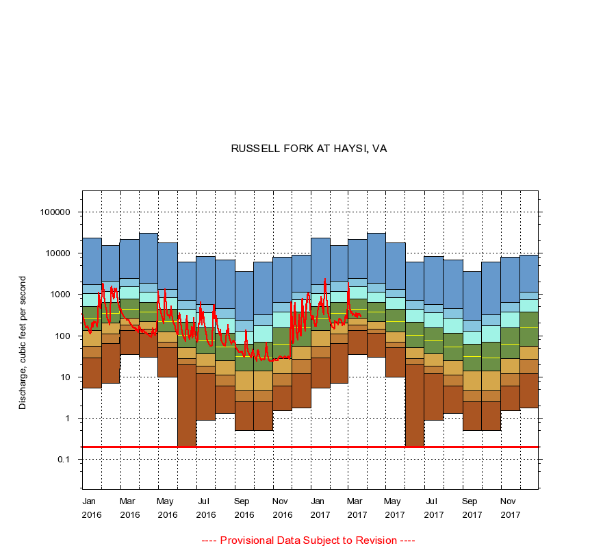
03208500
RUSSELL FORK AT HAYSI, VA
|
Minimum daily flow
|
|
|
5th percentile
|
|
|
|
10th percentile
|
|
|
|
|
25th percentile
|
|
|
|
|
|
Median
|
|
|
|
|
|
|
75th percentile
|
|
|
|
|
|
|
|
90th percentile
|
|
|
|
|
|
|
|
|
95th percentile
|
|
|
|
|
|
|
|
|
|
Maximum daily flow
|
|
|
|
|
|
|
|
|
|
|
|
Years of record
|
January
|
5.40
|
29.0
|
56.0
|
136
|
264
|
516
|
1,050
|
1,720
|
23,000
|
|
89
|
February
|
7.00
|
65.0
|
110
|
205
|
354
|
646
|
1,190
|
2,070
|
15,500
|
|
89
|
March
|
35.0
|
136
|
179
|
268
|
440
|
781
|
1,550
|
2,420
|
21,800
|
|
89
|
April
|
30.0
|
113
|
142
|
218
|
370
|
645
|
1,150
|
1,860
|
30,600
|
|
89
|
May
|
10.0
|
52.0
|
70.0
|
124
|
219
|
432
|
853
|
1,330
|
17,500
|
|
89
|
June
|
0.20
|
20.0
|
28.0
|
52.0
|
102
|
208
|
439
|
732
|
6,040
|
|
89
|
July
|
0.90
|
12.0
|
18.0
|
36.0
|
74.0
|
158
|
356
|
569
|
8,240
|
|
89
|
August
|
1.30
|
6.00
|
11.0
|
25.0
|
54.0
|
116
|
265
|
446
|
6,850
|
|
90
|
September
|
0.50
|
2.50
|
4.71
|
14.0
|
31.0
|
62.0
|
127
|
236
|
3,630
|
|
90
|
October
|
0.50
|
2.50
|
4.70
|
14.0
|
29.0
|
70.0
|
175
|
324
|
6,190
|
|
89
|
November
|
1.50
|
6.00
|
12.0
|
28.0
|
62.5
|
158
|
371
|
644
|
7,920
|
|
89
|
December
|
1.80
|
12.0
|
27.0
|
56.0
|
153
|
376
|
750
|
1,150
|
8,800
|
|
89
|
|
|
Instantaneous minimum flow for period of record =
0.20
cubic feet per second.
The current daily value for 03/22/2017 is 291.0 cubic feet per second.
----
Provisional Data Subject to Revision ----
|