|
03208950
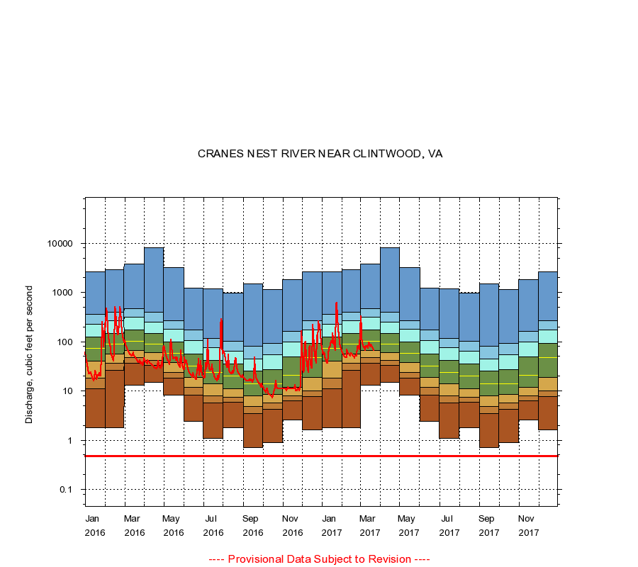
CRANES NEST RIVER NEAR CLINTWOOD, VA
|
Minimum daily flow
|
|
|
5th percentile
|
|
|
|
10th percentile
|
|
|
|
|
25th percentile
|
|
|
|
|
|
Median
|
|
|
|
|
|
|
75th percentile
|
|
|
|
|
|
|
|
90th percentile
|
|
|
|
|
|
|
|
|
95th percentile
|
|
|
|
|
|
|
|
|
|
Maximum daily flow
|
|
|
|
|
|
|
|
|
|
|
|
Years of record
|
January
|
1.80
|
11.0
|
18.0
|
40.0
|
72.0
|
124
|
227
|
354
|
2,630
|
|
52
|
February
|
1.80
|
26.0
|
36.0
|
57.0
|
90.0
|
147
|
265
|
400
|
2,850
|
|
52
|
March
|
13.0
|
36.0
|
47.0
|
67.0
|
102
|
171
|
313
|
469
|
3,750
|
|
52
|
April
|
15.0
|
33.0
|
41.0
|
59.0
|
90.0
|
145
|
246
|
401
|
8,000
|
|
52
|
May
|
8.10
|
18.0
|
24.0
|
38.2
|
58.0
|
98.0
|
177
|
268
|
3,160
|
|
52
|
June
|
2.40
|
8.30
|
12.0
|
19.0
|
32.0
|
56.0
|
104
|
171
|
1,230
|
|
52
|
July
|
1.10
|
5.70
|
8.00
|
14.0
|
24.0
|
41.0
|
76.0
|
116
|
1,170
|
|
52
|
August
|
1.80
|
5.80
|
7.33
|
11.2
|
20.0
|
35.0
|
65.0
|
101
|
981
|
|
52
|
September
|
0.70
|
3.50
|
4.80
|
8.00
|
14.0
|
25.0
|
45.0
|
81.9
|
1,500
|
|
52
|
October
|
0.90
|
4.20
|
5.63
|
8.40
|
14.0
|
27.0
|
53.7
|
93.7
|
1,140
|
|
52
|
November
|
2.60
|
6.20
|
7.81
|
12.0
|
21.0
|
49.0
|
100
|
163
|
1,810
|
|
52
|
December
|
1.60
|
7.60
|
9.90
|
19.0
|
47.0
|
93.0
|
175
|
267
|
2,610
|
|
52
|
|
|
Instantaneous minimum flow for period of record =
0.48
cubic feet per second.
The current daily value for 03/22/2017 is 67.0 cubic feet per second.
----
Provisional Data Subject to Revision ----
|