|
03473000
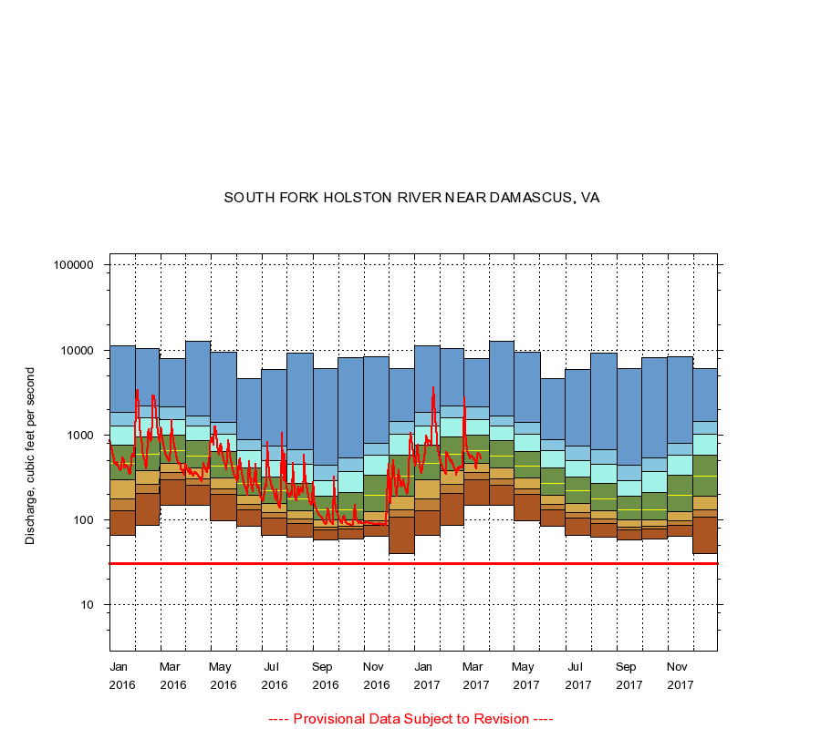
SOUTH FORK HOLSTON RIVER NEAR DAMASCUS, VA
|
Minimum daily flow
|
|
|
5th percentile
|
|
|
|
10th percentile
|
|
|
|
|
25th percentile
|
|
|
|
|
|
Median
|
|
|
|
|
|
|
75th percentile
|
|
|
|
|
|
|
|
90th percentile
|
|
|
|
|
|
|
|
|
95th percentile
|
|
|
|
|
|
|
|
|
|
Maximum daily flow
|
|
|
|
|
|
|
|
|
|
|
|
Years of record
|
January
|
65.0
|
128
|
175
|
297
|
464
|
750
|
1,260
|
1,820
|
11,200
|
|
84
|
February
|
86.0
|
204
|
260
|
380
|
591
|
938
|
1,580
|
2,180
|
10,400
|
|
84
|
March
|
146
|
292
|
356
|
456
|
657
|
991
|
1,510
|
2,130
|
7,840
|
|
84
|
April
|
146
|
254
|
301
|
406
|
568
|
852
|
1,260
|
1,680
|
12,800
|
|
84
|
May
|
97.0
|
198
|
230
|
307
|
432
|
636
|
1,020
|
1,410
|
9,400
|
|
84
|
June
|
83.0
|
130
|
152
|
194
|
268
|
407
|
657
|
881
|
4,620
|
|
84
|
July
|
65.0
|
105
|
122
|
156
|
218
|
316
|
502
|
735
|
5,820
|
|
84
|
August
|
62.0
|
91.0
|
102
|
127
|
176
|
270
|
444
|
664
|
9,180
|
|
84
|
September
|
58.0
|
75.0
|
82.0
|
100
|
132
|
188
|
289
|
436
|
6,000
|
|
84
|
October
|
59.0
|
77.0
|
84.0
|
100
|
132
|
207
|
366
|
534
|
8,150
|
|
84
|
November
|
64.0
|
85.0
|
96.0
|
123
|
192
|
333
|
576
|
793
|
8,340
|
|
84
|
December
|
40.0
|
106
|
129
|
190
|
323
|
582
|
1,010
|
1,420
|
5,980
|
|
84
|
|
|
Instantaneous minimum flow for period of record =
30.0
cubic feet per second.
The current daily value for 03/22/2017 is 517.0 cubic feet per second.
----
Provisional Data Subject to Revision ----
|