|
03475000
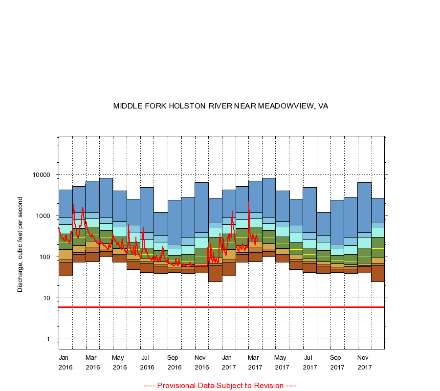
MIDDLE FORK HOLSTON RIVER NEAR MEADOWVIEW, VA
|
Minimum daily flow
|
|
|
5th percentile
|
|
|
|
10th percentile
|
|
|
|
|
25th percentile
|
|
|
|
|
|
Median
|
|
|
|
|
|
|
75th percentile
|
|
|
|
|
|
|
|
90th percentile
|
|
|
|
|
|
|
|
|
95th percentile
|
|
|
|
|
|
|
|
|
|
Maximum daily flow
|
|
|
|
|
|
|
|
|
|
|
|
Years of record
|
January
|
34.0
|
73.0
|
86.0
|
150
|
227
|
360
|
613
|
900
|
4,290
|
|
39
|
February
|
74.0
|
115
|
129
|
188
|
304
|
488
|
807
|
1,230
|
5,170
|
|
39
|
March
|
76.0
|
129
|
174
|
241
|
349
|
536
|
840
|
1,200
|
7,040
|
|
39
|
April
|
101
|
135
|
155
|
210
|
295
|
438
|
644
|
890
|
8,220
|
|
39
|
May
|
74.0
|
105
|
116
|
158
|
218
|
312
|
529
|
720
|
4,100
|
|
40
|
June
|
49.0
|
76.0
|
87.0
|
111
|
150
|
222
|
381
|
599
|
2,580
|
|
40
|
July
|
42.0
|
69.0
|
77.0
|
91.0
|
116
|
165
|
263
|
396
|
4,880
|
|
40
|
August
|
40.0
|
59.0
|
66.0
|
77.0
|
99.5
|
142
|
229
|
337
|
1,200
|
|
40
|
September
|
42.0
|
51.0
|
57.0
|
69.0
|
83.0
|
110
|
154
|
204
|
2,380
|
|
40
|
October
|
39.0
|
51.0
|
58.0
|
65.0
|
78.0
|
115
|
187
|
297
|
2,870
|
|
39
|
November
|
41.0
|
58.0
|
61.0
|
70.0
|
101
|
165
|
294
|
392
|
6,410
|
|
39
|
December
|
25.0
|
62.0
|
69.0
|
95.0
|
160
|
302
|
506
|
706
|
2,690
|
|
39
|
|
|
Instantaneous minimum flow for period of record =
6.00
cubic feet per second.
The current daily value for 03/22/2017 is 250.0 cubic feet per second.
----
Provisional Data Subject to Revision ----
|