|
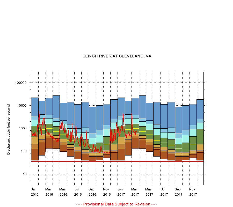
03524000
CLINCH RIVER AT CLEVELAND, VA
|
Minimum daily flow
|
|
|
5th percentile
|
|
|
|
10th percentile
|
|
|
|
|
25th percentile
|
|
|
|
|
|
Median
|
|
|
|
|
|
|
75th percentile
|
|
|
|
|
|
|
|
90th percentile
|
|
|
|
|
|
|
|
|
95th percentile
|
|
|
|
|
|
|
|
|
|
Maximum daily flow
|
|
|
|
|
|
|
|
|
|
|
|
Years of record
|
January
|
40.0
|
125
|
200
|
420
|
710
|
1,250
|
2,310
|
3,480
|
22,200
|
|
95
|
February
|
65.0
|
246
|
328
|
556
|
896
|
1,500
|
2,720
|
4,030
|
16,000
|
|
95
|
March
|
131
|
377
|
459
|
618
|
975
|
1,600
|
2,770
|
3,930
|
20,900
|
|
95
|
April
|
129
|
305
|
354
|
487
|
719
|
1,210
|
1,990
|
2,840
|
27,800
|
|
95
|
May
|
97.0
|
192
|
233
|
334
|
523
|
874
|
1,520
|
2,210
|
13,000
|
|
95
|
June
|
59.0
|
118
|
143
|
197
|
298
|
516
|
998
|
1,490
|
14,400
|
|
95
|
July
|
45.0
|
92.0
|
111
|
153
|
232
|
374
|
658
|
977
|
11,100
|
|
95
|
August
|
39.0
|
75.0
|
89.0
|
119
|
185
|
326
|
651
|
1,060
|
14,400
|
|
95
|
September
|
37.0
|
58.0
|
68.0
|
88.0
|
133
|
202
|
375
|
616
|
8,740
|
|
95
|
October
|
42.0
|
59.0
|
68.0
|
89.0
|
125
|
234
|
515
|
852
|
9,990
|
|
95
|
November
|
51.0
|
71.0
|
84.0
|
110
|
206
|
435
|
932
|
1,390
|
11,400
|
|
95
|
December
|
40.0
|
86.0
|
109
|
198
|
467
|
939
|
1,740
|
2,630
|
18,400
|
|
95
|
|
|
Instantaneous minimum flow for period of record =
35.0
cubic feet per second.
The current daily value for 03/22/2017 is 696.0 cubic feet per second.
----
Provisional Data Subject to Revision ----
|