USGS - science for a changing world
Virginia DEQ

Virginia Water Science Center

 
Now available online...

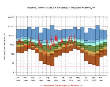
Duration Plots for Selected Streamgage Locations in Virginia


duration_plot.

Streamflow-duration plots, which depict the flow-duration curves of daily-streamflow data grouped by months, are now available for streamflow gages in Virginia. Flow-duration plots are used to place current streamflow conditions in context of historic flow-conditions. Combined with other information such as ground-water levels, precipitation, and soil moisture, flow-duration plots can help local government agencies and water-resource managers assess regional drought conditions.

Currently available plots include statistics of daily streamflow data and the current daily streamflow data. Additional plots based on 7-day, 14-day, and 28-day running averages of the streamflow data are planned.

 
---- Provisional Data Subject to Revision ----

Accessibility FOIA Privacy Policies and Notices

Take Pride in America logo USA.gov logo U.S. Department of the Interior | U.S. Geological Survey
URL: http://va.water.usgs.gov/duration_plots/dp_announcement.htm
Page Contact Information: Virginia WSC Webmaster
Page Last Modified: 04/23/2007 09:23:44 AM