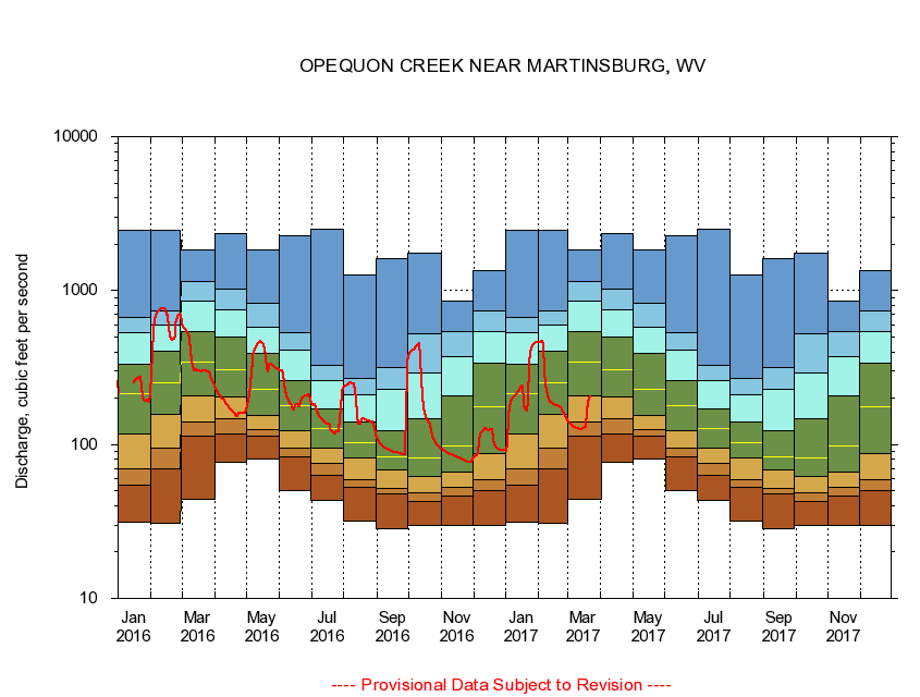
USGS - science for a changing world
Virginia DEQ

Virginia Water Science Center

 
  Duration Plot and Table of 14-Day Average Streamflow
 
01616500 OPEQUON CREEK NEAR MARTINSBURG, WV
LOCATION.--Latitude 39°25'25", Longitude 77°56'20", North American Datum of 1927
                    Berkeley County, W. Va., Hydrologic Unit 02070004.
DRAINAGE AREA.--273 square miles.
PERIOD OF RECORD.--May 1905 to July 1906, July 1947 to current year.
DURATION STATISTIC COMPUTATION PERIOD.--All data through September 2015.
REGULATION.--Some diurnal fluctuation at low flow caused by upstream mills in Virginia and since July 18, 1988, by wastewater treatment plant, downstream from Opequon Creek near Berryville, Va (01615000); drainage area 58.2 mi2.
GAGE OPERATION.--U.S. Geological Survey, West Virginia Water Science Center.

     Duration Plot with 14-Day Average Streamflow Conditions
Provisional Data Subject to Revision
01616500 plot. 
OPEQUON CREEK NEAR MARTINSBURG, WV
Provisional Data Subject to Revision


The current 14-day running-average value for 03/22/2017 is 204.71 cubic feet per second.

  explanation   Percentile Description Duration Plot Description 28 Day 14 Day 7 Day Daily


      Duration Table of 14-Day Average Streamflow
           
Flow values in cubic feet per second


                01616500     OPEQUON CREEK NEAR MARTINSBURG, WV

   Minimum daily flow
   5th percentile
 
   10th percentile
 
   25th percentile
 
 
   Median
 
 
   75th percentile


   90th percentile


   95th percentile


   Maximum daily flow
         
Years of record
January
31.2
54.2
69.5
117
214
330
529
664
2,450
 
68
February
30.6
69.1
95.1
156
251
406
600
743
2,470
 
68
March
44.4
113
139
206
345
539
850
1,140
1,830
 
68
April
76.2
117
148
205
306
499
753
1,020
2,360
 
68
May
79.9
113
125
154
228
390
581
821
1,850
 
68
June
50.1
83.7
94.9
123
180
260
408
536
2,260
 
68
July
43.0
63.2
75.3
95.2
127
169
258
325
2,510
 
68
August
31.9
52.5
59.1
82.0
102
139
212
270
1,270
 
68
September
28.6
47.4
52.0
67.9
83.4
123
230
316
1,620
 
69
October
29.9
42.6
48.4
61.9
82.1
147
292
521
1,740
 
68
November
29.9
46.4
52.7
66.5
98.2
208
373
539
852
 
68
December
29.9
50.4
58.8
86.6
175
337
545
737
1,350
 
68


The current 14-day running-average value for 03/22/2017 is 204.71 cubic feet per second.

---- Provisional Data Subject to Revision ----

Accessibility FOIA Privacy Policies and Notices

Take Pride in America logo USA.gov logo U.S. Department of the Interior | U.S. Geological Survey
URL: http://va.water.usgs.gov/duration_plots/htm_14/dp01616500.htm
Page Contact Information: Virginia WSC Webmaster
Page Last Modified: 6/19/2016