|
01622000
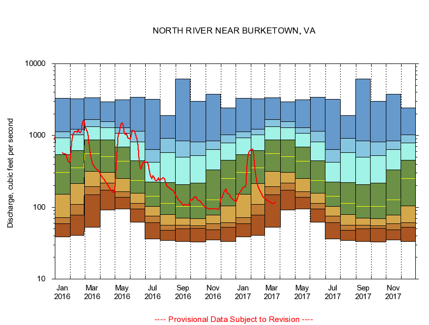
NORTH RIVER NEAR BURKETOWN, VA
|
Minimum daily flow
|
|
|
5th percentile
|
|
|
|
10th percentile
|
|
|
|
|
25th percentile
|
|
|
|
|
|
Median
|
|
|
|
|
|
|
75th percentile
|
|
|
|
|
|
|
|
90th percentile
|
|
|
|
|
|
|
|
|
95th percentile
|
|
|
|
|
|
|
|
|
|
Maximum daily flow
|
|
|
|
|
|
|
|
|
|
|
|
Years of record
|
January
|
38.7
|
58.7
|
71.4
|
151
|
308
|
545
|
923
|
1,120
|
3,290
|
|
86
|
February
|
40.8
|
77.5
|
109
|
213
|
354
|
614
|
1,020
|
1,230
|
3,270
|
|
86
|
March
|
52.4
|
150
|
195
|
314
|
558
|
868
|
1,320
|
1,670
|
3,360
|
|
86
|
April
|
91.9
|
173
|
219
|
306
|
510
|
874
|
1,280
|
1,570
|
2,940
|
|
86
|
May
|
94.9
|
137
|
164
|
252
|
438
|
692
|
1,080
|
1,280
|
3,120
|
|
86
|
June
|
61.9
|
94.1
|
114
|
156
|
234
|
444
|
816
|
1,140
|
3,400
|
|
87
|
July
|
36.0
|
61.0
|
75.2
|
103
|
142
|
225
|
426
|
640
|
3,200
|
|
88
|
August
|
34.4
|
48.0
|
56.3
|
78.9
|
114
|
222
|
582
|
907
|
1,890
|
|
88
|
September
|
33.5
|
49.9
|
56.0
|
70.1
|
102
|
207
|
502
|
840
|
6,140
|
|
88
|
October
|
33.1
|
50.6
|
55.0
|
69.8
|
102
|
218
|
524
|
814
|
3,000
|
|
87
|
November
|
35.0
|
48.6
|
59.3
|
77.9
|
128
|
333
|
632
|
847
|
3,790
|
|
86
|
December
|
33.6
|
52.9
|
60.6
|
104
|
251
|
456
|
782
|
1,020
|
2,430
|
|
86
|
|
|
|