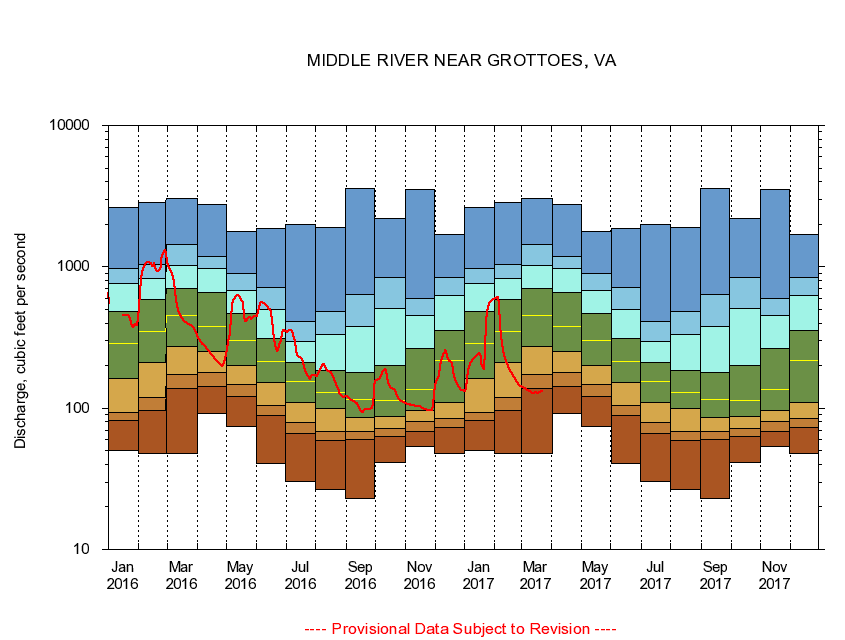
USGS - science for a changing world
Virginia DEQ

Virginia Water Science Center

 
  Duration Plot and Table of 14-Day Average Streamflow
 
01625000 MIDDLE RIVER NEAR GROTTOES, VA
LOCATION.--Latitude 38°15'42", Longitude 78°51'44", North American Datum of 1927,
                    Augusta County, VA, Hydrologic Unit 02070005.
DRAINAGE AREA.--373 square miles.
PERIOD OF RECORD.--April 1927 to current year. Records for February 1925 to September 1926, published in WSP 601 and 621, are unreliable and should not be used.
DURATION STATISTIC COMPUTATION PERIOD.--All data through September 2015.
REGULATION.--Some small diurnal fluctuation at low flow caused by mills upstream. Discharge includes discharges at treatment plants upstream, much of which is diverted from another drainage basin for industrial and municipal supply. Wastwater treatment upstream estimated input 6.4 cfs.
GAGE OPERATION.--Virginia Department of Environmental Quality - Water Division.

     Duration Plot with 14-Day Average Streamflow Conditions
Provisional Data Subject to Revision
01625000 plot. 
MIDDLE RIVER NEAR GROTTOES, VA
Provisional Data Subject to Revision


The current 14-day running-average value for 03/22/2017 is 131.36 cubic feet per second.

  explanation   Percentile Description Duration Plot Description 28 Day 14 Day 7 Day Daily


      Duration Table of 14-Day Average Streamflow
           
Flow values in cubic feet per second


                01625000     MIDDLE RIVER NEAR GROTTOES, VA

   Minimum daily flow
   5th percentile
 
   10th percentile
 
   25th percentile
 
 
   Median
 
 
   75th percentile


   90th percentile


   95th percentile


   Maximum daily flow
         
Years of record
January
50.4
82.4
92.7
161
285
480
762
978
2,630
 
88
February
47.8
96.9
119
211
347
585
833
1,040
2,870
 
88
March
47.4
138
172
272
455
706
1,030
1,440
3,050
 
88
April
91.1
142
178
252
377
659
973
1,180
2,780
 
88
May
74.6
120
147
201
299
465
684
903
1,790
 
88
June
40.4
89.0
104
151
214
309
500
710
1,880
 
88
July
30.4
66.0
79.1
110
154
210
298
408
1,990
 
88
August
26.4
59.1
68.4
98.7
130
185
331
480
1,900
 
88
September
23.1
60.5
68.4
85.4
115
179
381
632
3,590
 
88
October
41.5
62.9
71.4
88.0
114
199
510
838
2,210
 
87
November
53.5
68.6
80.0
95.9
136
263
451
598
3,550
 
88
December
47.5
72.9
84.7
110
216
352
623
837
1,700
 
88


The current 14-day running-average value for 03/22/2017 is 131.36 cubic feet per second.

---- Provisional Data Subject to Revision ----

Accessibility FOIA Privacy Policies and Notices

Take Pride in America logo USA.gov logo U.S. Department of the Interior | U.S. Geological Survey
URL: http://va.water.usgs.gov/duration_plots/htm_14/dp01625000.htm
Page Contact Information: Virginia WSC Webmaster
Page Last Modified: 6/19/2016