|
01626850
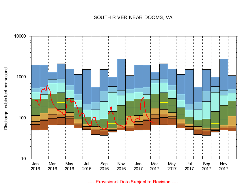
SOUTH RIVER NEAR DOOMS, VA
|
Minimum daily flow
|
|
|
5th percentile
|
|
|
|
10th percentile
|
|
|
|
|
25th percentile
|
|
|
|
|
|
Median
|
|
|
|
|
|
|
75th percentile
|
|
|
|
|
|
|
|
90th percentile
|
|
|
|
|
|
|
|
|
95th percentile
|
|
|
|
|
|
|
|
|
|
Maximum daily flow
|
|
|
|
|
|
|
|
|
|
|
|
Years of record
|
January
|
50.1
|
69.2
|
82.3
|
116
|
175
|
291
|
431
|
542
|
1,990
|
|
32
|
February
|
51.0
|
87.9
|
93.4
|
131
|
187
|
292
|
379
|
567
|
1,960
|
|
32
|
March
|
67.5
|
97.7
|
123
|
174
|
260
|
391
|
715
|
879
|
1,320
|
|
32
|
April
|
68.0
|
103
|
124
|
162
|
238
|
419
|
729
|
917
|
2,120
|
|
32
|
May
|
67.2
|
96.6
|
109
|
135
|
198
|
300
|
480
|
641
|
1,590
|
|
32
|
June
|
57.6
|
68.4
|
75.9
|
93.0
|
119
|
178
|
271
|
385
|
1,170
|
|
33
|
July
|
51.8
|
56.4
|
61.9
|
70.1
|
84.9
|
104
|
158
|
216
|
1,530
|
|
33
|
August
|
39.4
|
50.3
|
54.5
|
62.3
|
70.8
|
88.3
|
160
|
242
|
564
|
|
33
|
September
|
37.5
|
47.9
|
52.0
|
57.4
|
66.8
|
94.1
|
251
|
449
|
1,540
|
|
34
|
October
|
45.0
|
49.7
|
51.6
|
56.5
|
72.6
|
145
|
425
|
585
|
1,010
|
|
33
|
November
|
51.2
|
57.1
|
60.6
|
67.5
|
90.5
|
203
|
362
|
479
|
2,810
|
|
33
|
December
|
48.0
|
55.8
|
63.8
|
112
|
176
|
262
|
405
|
507
|
1,090
|
|
32
|
|
|
|