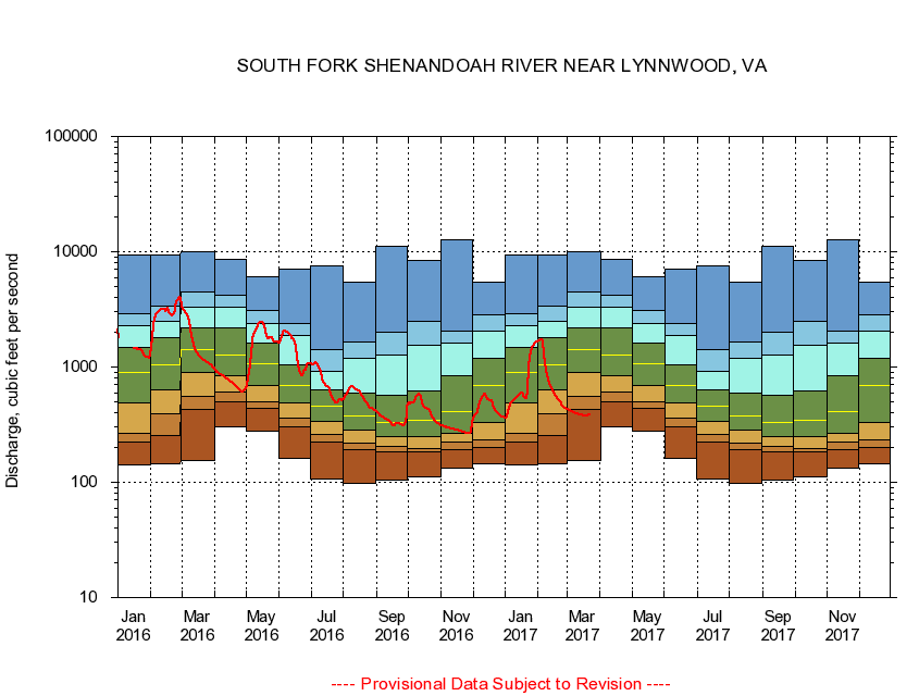
USGS - science for a changing world
Virginia DEQ

Virginia Water Science Center

 
  Duration Plot and Table of 14-Day Average Streamflow
 
01628500 SOUTH FORK SHENANDOAH RIVER NEAR LYNNWOOD, VA
LOCATION.--Latitude 38°19'21", Longitude 78°45'18", North American Datum of 1927,
                    Rockingham County, VA, Hydrologic Unit 02070005.
DRAINAGE AREA.--1,079 square miles.
PERIOD OF RECORD.--September 1930 to current year.
DURATION STATISTIC COMPUTATION PERIOD.--All data through September 2015.
REGULATION.--Diurnal fluctuation at low flow prior to 1960 caused by mill at Lynnwood and since by irrigation during summer months.
GAGE OPERATION.--Virginia Department of Environmental Quality - Water Division.

     Duration Plot with 14-Day Average Streamflow Conditions
Provisional Data Subject to Revision
01628500 plot. 
SOUTH FORK SHENANDOAH RIVER NEAR LYNNWOOD, VA
Provisional Data Subject to Revision


The current 14-day running-average value for 03/22/2017 is 384.5 cubic feet per second.

  explanation   Percentile Description Duration Plot Description 28 Day 14 Day 7 Day Daily


      Duration Table of 14-Day Average Streamflow
           
Flow values in cubic feet per second


                01628500     SOUTH FORK SHENANDOAH RIVER NEAR LYNNWOOD, VA

   Minimum daily flow
   5th percentile
 
   10th percentile
 
   25th percentile
 
 
   Median
 
 
   75th percentile


   90th percentile


   95th percentile


   Maximum daily flow
         
Years of record
January
141
225
268
485
906
1,490
2,300
2,920
9,410
 
85
February
145
257
397
627
1,050
1,800
2,490
3,350
9,400
 
85
March
155
432
551
904
1,430
2,200
3,300
4,490
10,100
 
85
April
302
494
609
848
1,280
2,180
3,270
4,190
8,660
 
85
May
277
434
495
696
1,070
1,620
2,380
3,100
6,020
 
85
June
160
306
362
491
690
1,050
1,890
2,400
7,080
 
85
July
107
221
261
337
458
629
923
1,410
7,560
 
85
August
97.4
191
220
285
376
589
1,190
1,660
5,430
 
85
September
105
184
203
249
329
564
1,270
2,020
11,100
 
85
October
111
185
196
248
342
619
1,560
2,480
8,370
 
84
November
132
192
225
268
411
843
1,600
2,050
12,600
 
85
December
144
201
231
330
691
1,190
2,070
2,820
5,390
 
85


The current 14-day running-average value for 03/22/2017 is 384.5 cubic feet per second.

---- Provisional Data Subject to Revision ----

Accessibility FOIA Privacy Policies and Notices

Take Pride in America logo USA.gov logo U.S. Department of the Interior | U.S. Geological Survey
URL: http://va.water.usgs.gov/duration_plots/htm_14/dp01628500.htm
Page Contact Information: Virginia WSC Webmaster
Page Last Modified: 6/19/2016