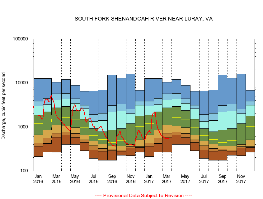
USGS - science for a changing world
Virginia DEQ

Virginia Water Science Center

 
  Duration Plot and Table of 14-Day Average Streamflow
 
01629500 SOUTH FORK SHENANDOAH RIVER NEAR NEAR LURAY, VA
LOCATION.--Latitude 38°38'46", Longitude 78°32'06", North American Datum of 1927,
                    Page County, VA, Hydrologic Unit 02070005.
DRAINAGE AREA.--1,372 square miles.
PERIOD OF RECORD.--April 1925 to September 1930, October 1938 to September 1951, June 1979 to current year.
DURATION STATISTIC COMPUTATION PERIOD.--All data through September 2015.
REGULATION.--Diurnal fluctuation at low and medium flows caused by the powerplant 10 miles above station.
GAGE OPERATION.--Virginia Department of Environmental Quality - Water Division.

     Duration Plot with 14-Day Average Streamflow Conditions
Provisional Data Subject to Revision
01629500 plot. 
SOUTH FORK SHENANDOAH RIVER NEAR LURAY, VA
Provisional Data Subject to Revision


The current 14-day running-average value for 03/22/2017 is 550.14 cubic feet per second.

  explanation   Percentile Description Duration Plot Description 28 Day 14 Day 7 Day Daily


      Duration Table of 14-Day Average Streamflow
           
Flow values in cubic feet per second


                01629500     SOUTH FORK SHENANDOAH RIVER NEAR LURAY, VA

   Minimum daily flow
   5th percentile
 
   10th percentile
 
   25th percentile
 
 
   Median
 
 
   75th percentile


   90th percentile


   95th percentile


   Maximum daily flow
         
Years of record
January
211
362
427
661
1,190
1,850
2,980
3,860
12,600
 
54
February
268
419
558
850
1,290
2,200
3,230
4,470
12,600
 
54
March
266
584
714
1,120
1,800
2,720
4,120
5,730
10,400
 
54
April
401
652
769
1,050
1,660
2,900
4,340
5,750
12,000
 
54
May
399
568
708
955
1,490
2,360
3,430
4,390
8,790
 
55
June
288
440
513
656
977
1,490
2,580
3,130
6,480
 
55
July
193
297
373
477
638
915
1,330
1,920
6,600
 
56
August
174
281
324
412
517
783
1,410
2,040
6,940
 
56
September
174
288
314
369
440
839
2,170
3,060
15,100
 
56
October
224
280
300
366
493
919
2,270
3,340
12,900
 
53
November
223
326
359
401
560
1,190
2,020
2,560
16,100
 
54
December
264
339
359
512
1,020
1,760
3,100
3,850
6,760
 
54


The current 14-day running-average value for 03/22/2017 is 550.14 cubic feet per second.

---- Provisional Data Subject to Revision ----

Accessibility FOIA Privacy Policies and Notices

Take Pride in America logo USA.gov logo U.S. Department of the Interior | U.S. Geological Survey
URL: http://va.water.usgs.gov/duration_plots/htm_14/dp01629500.htm
Page Contact Information: Virginia WSC Webmaster
Page Last Modified: 6/19/2016