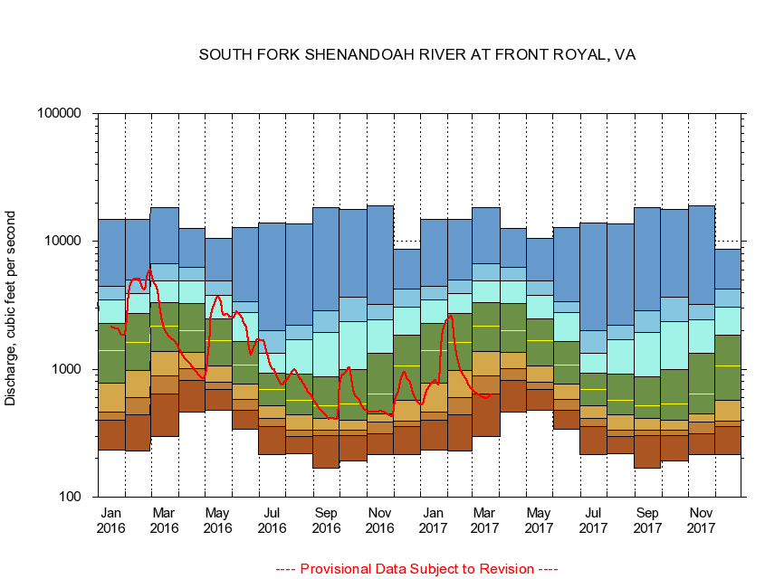
USGS - science for a changing world
Virginia DEQ

Virginia Water Science Center

 
  Duration Plot and Table of 14-Day Average Streamflow
 
01631000 SOUTH FORK SHENANDOAH RIVER AT FRONT ROYAL, VA
LOCATION.--Latitude 38°54'50", Longitude 78°12'40", North American Datum of 1927,
                    Warren County, VA, Hydrologic Unit 02070005.
DRAINAGE AREA.--1,634 square miles.
PERIOD OF RECORD.--June 1899 to September 1906, October 1930 to current year. Monthly discharge only for some periods, published in WSP 1302.
DURATION STATISTIC COMPUTATION PERIOD.--All data through September 2015.
REGULATION.--Flow at low and medium stages is regulated by operation of powerplants above station prior to 1954, occasional large diurnal fluctuation thereafter.
GAGE OPERATION.--U.S. Geological Survey, Virginia Water Science Center.

     Duration Plot with 14-Day Average Streamflow Conditions
Provisional Data Subject to Revision
01631000 plot. 
SOUTH FORK SHENANDOAH RIVER AT FRONT ROYAL, VA
Provisional Data Subject to Revision


The current 14-day running-average value for 03/22/2017 is 629.93 cubic feet per second.

  explanation   Percentile Description Duration Plot Description 28 Day 14 Day 7 Day Daily


      Duration Table of 14-Day Average Streamflow
           
Flow values in cubic feet per second


                01631000     SOUTH FORK SHENANDOAH RIVER AT FRONT ROYAL, VA

   Minimum daily flow
   5th percentile
 
   10th percentile
 
   25th percentile
 
 
   Median
 
 
   75th percentile


   90th percentile


   95th percentile


   Maximum daily flow
         
Years of record
January
234
399
464
774
1,390
2,280
3,480
4,440
14,800
 
85
February
230
440
604
979
1,610
2,710
3,900
5,030
14,800
 
85
March
298
638
885
1,370
2,160
3,310
4,920
6,720
18,300
 
85
April
461
813
1,010
1,350
2,000
3,270
4,880
6,280
12,600
 
85
May
479
693
797
1,060
1,680
2,480
3,760
4,880
10,500
 
85
June
340
480
580
768
1,080
1,650
2,770
3,350
12,900
 
85
July
216
358
414
520
700
937
1,340
1,990
14,000
 
85
August
220
296
335
441
569
919
1,690
2,220
13,600
 
85
September
168
303
334
413
517
878
1,930
2,860
18,500
 
85
October
192
303
332
397
533
995
2,340
3,660
17,700
 
84
November
216
313
384
450
638
1,340
2,420
3,230
19,000
 
85
December
216
359
394
568
1,070
1,840
3,080
4,240
8,720
 
85


The current 14-day running-average value for 03/22/2017 is 629.93 cubic feet per second.

---- Provisional Data Subject to Revision ----

Accessibility FOIA Privacy Policies and Notices

Take Pride in America logo USA.gov logo U.S. Department of the Interior | U.S. Geological Survey
URL: http://va.water.usgs.gov/duration_plots/htm_14/dp01631000.htm
Page Contact Information: Virginia WSC Webmaster
Page Last Modified: 6/19/2016