|
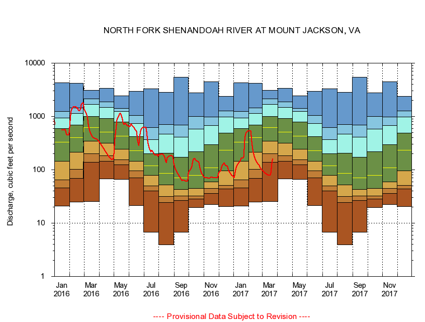
01633000
NORTH FORK SHENANDOAH RIVER AT MOUNT JACKSON, VA
|
Minimum daily flow
|
|
|
5th percentile
|
|
|
|
10th percentile
|
|
|
|
|
25th percentile
|
|
|
|
|
|
Median
|
|
|
|
|
|
|
75th percentile
|
|
|
|
|
|
|
|
90th percentile
|
|
|
|
|
|
|
|
|
95th percentile
|
|
|
|
|
|
|
|
|
|
Maximum daily flow
|
|
|
|
|
|
|
|
|
|
|
|
Years of record
|
January
|
21.0
|
45.8
|
65.0
|
146
|
331
|
589
|
931
|
1,230
|
4,250
|
|
72
|
February
|
25.1
|
68.4
|
102
|
213
|
400
|
691
|
1,130
|
1,460
|
4,180
|
|
72
|
March
|
25.4
|
138
|
201
|
343
|
617
|
1,010
|
1,670
|
2,130
|
3,080
|
|
72
|
April
|
68.0
|
146
|
185
|
313
|
512
|
907
|
1,470
|
1,890
|
3,400
|
|
72
|
May
|
66.8
|
124
|
155
|
242
|
432
|
783
|
1,250
|
1,410
|
2,450
|
|
72
|
June
|
21.6
|
70.4
|
96.2
|
144
|
229
|
419
|
740
|
1,040
|
2,950
|
|
72
|
July
|
6.81
|
39.8
|
50.2
|
77.9
|
118
|
201
|
371
|
615
|
3,280
|
|
72
|
August
|
3.94
|
24.4
|
31.5
|
52.6
|
85.1
|
207
|
467
|
705
|
2,840
|
|
72
|
September
|
6.78
|
26.7
|
32.3
|
42.8
|
70.0
|
174
|
406
|
692
|
5,440
|
|
72
|
October
|
19.8
|
28.4
|
32.6
|
44.9
|
78.5
|
219
|
576
|
1,000
|
2,770
|
|
71
|
November
|
22.5
|
35.7
|
44.4
|
59.5
|
110
|
298
|
677
|
971
|
4,460
|
|
72
|
December
|
20.4
|
43.4
|
51.4
|
96.1
|
235
|
489
|
978
|
1,270
|
2,390
|
|
72
|
|
|
|