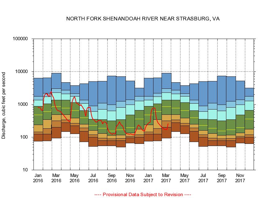
USGS - science for a changing world
Virginia DEQ

Virginia Water Science Center

 
  Duration Plot and Table of 14-Day Average Streamflow
 
01634000 NORTH FORK SHENANDOAH RIVER NEAR STRASBURG, VA
LOCATION.--Latitude 38°58'36", Longitude 78°20'11", North American Datum of 1927,
                    Warren County, VA, Hydrologic Unit 02070006.
DRAINAGE AREA.--770 square miles.
PERIOD OF RECORD.--April 1925 to current year.
DURATION STATISTIC COMPUTATION PERIOD.--All data through September 2015.
REGULATION.--Large diurnal fluctuation at low and medium flow caused by a hydroelectric plant upstream, and from other unknown sources.
GAGE OPERATION.--U.S. Geological Survey, Virginia Water Science Center.

     Duration Plot with 14-Day Average Streamflow Conditions
Provisional Data Subject to Revision
01634000 plot. 
NORTH FORK SHENANDOAH RIVER NEAR STRASBURG, VA
Provisional Data Subject to Revision


The current 14-day running-average value for 03/22/2017 is 255.5 cubic feet per second.

  explanation   Percentile Description Duration Plot Description 28 Day 14 Day 7 Day Daily


      Duration Table of 14-Day Average Streamflow
           
Flow values in cubic feet per second


                01634000     NORTH FORK SHENANDOAH RIVER NEAR STRASBURG, VA

   Minimum daily flow
   5th percentile
 
   10th percentile
 
   25th percentile
 
 
   Median
 
 
   75th percentile


   90th percentile


   95th percentile


   Maximum daily flow
         
Years of record
January
76.0
124
144
238
473
884
1,350
1,770
6,380
 
90
February
76.9
124
183
346
612
1,040
1,730
2,200
6,430
 
90
March
93.9
202
319
493
856
1,370
2,300
3,010
8,880
 
90
April
148
277
339
490
774
1,350
2,080
2,720
4,710
 
90
May
128
224
265
384
651
1,130
1,770
2,120
3,760
 
91
June
71.6
151
190
248
391
646
1,060
1,370
4,310
 
91
July
52.0
100
120
161
229
354
602
896
4,950
 
91
August
54.2
79.6
93.1
130
186
346
701
1,080
5,060
 
91
September
54.4
78.0
89.2
115
155
313
634
978
7,330
 
91
October
49.8
79.3
91.4
117
168
344
801
1,250
7,110
 
90
November
66.6
96.4
107
135
196
479
972
1,380
5,240
 
90
December
62.8
101
120
177
357
659
1,260
1,750
3,190
 
90


The current 14-day running-average value for 03/22/2017 is 255.5 cubic feet per second.

---- Provisional Data Subject to Revision ----

Accessibility FOIA Privacy Policies and Notices

Take Pride in America logo USA.gov logo U.S. Department of the Interior | U.S. Geological Survey
URL: http://va.water.usgs.gov/duration_plots/htm_14/dp01634000.htm
Page Contact Information: Virginia WSC Webmaster
Page Last Modified: 6/19/2016