|
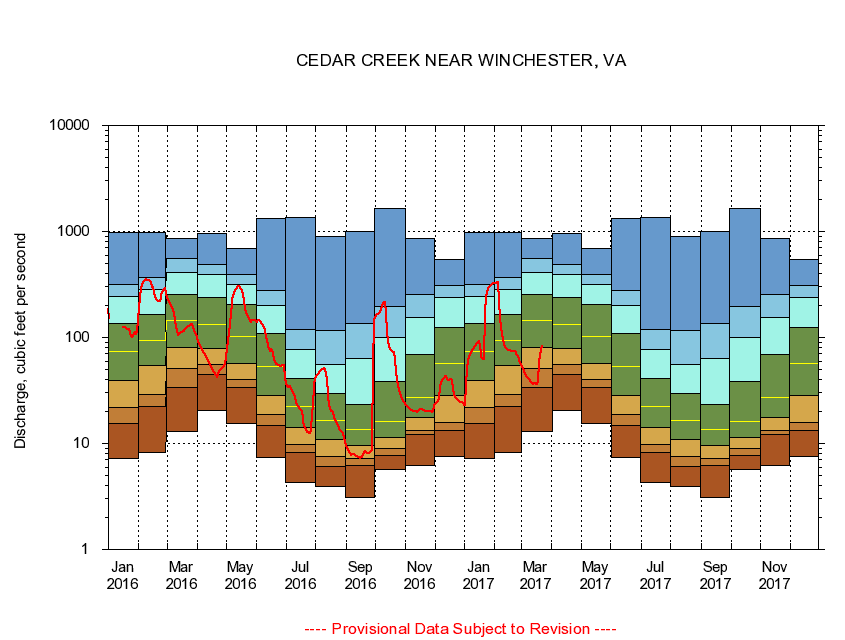
01634500
CEDAR CREEK NEAR WINCHESTER, VA
|
Minimum daily flow
|
|
|
5th percentile
|
|
|
|
10th percentile
|
|
|
|
|
25th percentile
|
|
|
|
|
|
Median
|
|
|
|
|
|
|
75th percentile
|
|
|
|
|
|
|
|
90th percentile
|
|
|
|
|
|
|
|
|
95th percentile
|
|
|
|
|
|
|
|
|
|
Maximum daily flow
|
|
|
|
|
|
|
|
|
|
|
|
Years of record
|
January
|
7.25
|
15.4
|
21.7
|
39.0
|
73.1
|
137
|
242
|
315
|
988
|
|
78
|
February
|
8.23
|
22.4
|
29.3
|
53.9
|
94.1
|
164
|
286
|
368
|
974
|
|
78
|
March
|
13.1
|
33.6
|
50.7
|
81.1
|
146
|
253
|
413
|
554
|
858
|
|
78
|
April
|
20.7
|
44.9
|
55.5
|
79.4
|
132
|
241
|
390
|
493
|
950
|
|
78
|
May
|
15.4
|
34.1
|
40.3
|
57.1
|
103
|
205
|
319
|
391
|
690
|
|
78
|
June
|
7.31
|
14.8
|
18.6
|
28.2
|
53.7
|
109
|
202
|
278
|
1,320
|
|
78
|
July
|
4.24
|
8.21
|
9.86
|
14.1
|
22.5
|
40.8
|
76.5
|
119
|
1,370
|
|
78
|
August
|
3.94
|
6.01
|
7.60
|
10.9
|
16.4
|
29.7
|
55.7
|
117
|
895
|
|
78
|
September
|
3.07
|
6.20
|
7.29
|
9.57
|
13.7
|
23.3
|
63.3
|
135
|
1,010
|
|
78
|
October
|
5.71
|
7.63
|
8.91
|
11.3
|
16.1
|
38.8
|
101
|
196
|
1,660
|
|
77
|
November
|
6.19
|
12.1
|
13.3
|
17.6
|
27.0
|
68.8
|
153
|
254
|
860
|
|
78
|
December
|
7.54
|
13.4
|
15.9
|
28.1
|
56.6
|
125
|
238
|
309
|
539
|
|
78
|
|
|
|