|
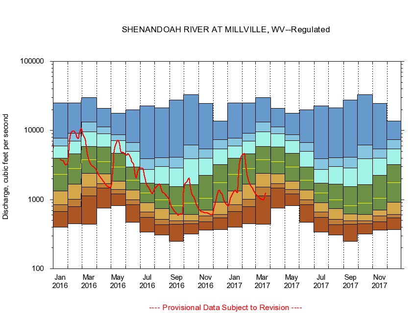
01636500
SHENANDOAH RIVER AT MILLVILLE, WV
|
Minimum daily flow
|
|
|
5th percentile
|
|
|
|
10th percentile
|
|
|
|
|
25th percentile
|
|
|
|
|
|
Median
|
|
|
|
|
|
|
75th percentile
|
|
|
|
|
|
|
|
90th percentile
|
|
|
|
|
|
|
|
|
95th percentile
|
|
|
|
|
|
|
|
|
|
Maximum daily flow
|
|
|
|
|
|
|
|
|
|
|
|
Years of record
|
January
|
398
|
669
|
840
|
1,330
|
2,310
|
3,950
|
5,970
|
7,780
|
25,000
|
|
101
|
February
|
450
|
797
|
1,010
|
1,680
|
2,800
|
4,580
|
7,030
|
9,130
|
25,200
|
|
101
|
March
|
442
|
1,130
|
1,520
|
2,400
|
3,810
|
5,840
|
9,550
|
13,200
|
29,800
|
|
101
|
April
|
748
|
1,480
|
1,690
|
2,350
|
3,550
|
5,800
|
8,990
|
11,300
|
20,900
|
|
101
|
May
|
822
|
1,210
|
1,400
|
1,840
|
2,960
|
4,670
|
7,120
|
8,750
|
17,700
|
|
101
|
June
|
471
|
840
|
1,000
|
1,370
|
1,920
|
2,960
|
5,030
|
6,710
|
20,000
|
|
101
|
July
|
341
|
557
|
667
|
908
|
1,240
|
1,730
|
2,750
|
3,940
|
22,800
|
|
101
|
August
|
309
|
436
|
520
|
740
|
999
|
1,670
|
3,030
|
4,050
|
21,200
|
|
101
|
September
|
248
|
438
|
492
|
620
|
824
|
1,540
|
2,890
|
4,090
|
27,500
|
|
102
|
October
|
318
|
450
|
495
|
608
|
890
|
1,650
|
3,920
|
6,170
|
33,100
|
|
101
|
November
|
361
|
476
|
583
|
712
|
1,040
|
2,250
|
3,990
|
5,390
|
24,600
|
|
101
|
December
|
371
|
548
|
610
|
919
|
1,760
|
3,190
|
5,440
|
7,410
|
13,800
|
|
101
|
|
|
|