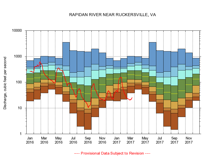
USGS - science for a changing world
Virginia DEQ

Virginia Water Science Center

 
  Duration Plot and Table of 14-Day Average Streamflow
 
01665500 RAPIDAN RIVER NEAR RUCKERSVILLE, VA.
LOCATION.--Latitude 38°16'50", Longitude 78°20'25", North American Datum of 1927,
                    Madison County, VA, Hydrologic Unit 02080103.
DRAINAGE AREA.--115 square miles.
PERIOD OF RECORD.--September 1942 to June 1995, October 1998 to current year.
DURATION STATISTIC COMPUTATION PERIOD.--All data through September 2015.
REGULATION.--Diversion after 1973, estimated 0.77 cfs.
GAGE OPERATION.--Virginia Department of Environmental Quality - Water Division.

     Duration Plot with 14-Day Average Streamflow Conditions
Provisional Data Subject to Revision
01665500 plot. 
RAPIDAN RIVER NEAR RUCKERSVILLE, VA
Provisional Data Subject to Revision


The current 14-day running-average value for 03/22/2017 is 24.93 cubic feet per second.

  explanation   Percentile Description Duration Plot Description 28 Day 14 Day 7 Day Daily


      Duration Table of 14-Day Average Streamflow
           
Flow values in cubic feet per second


                01665500     RAPIDAN RIVER NEAR RUCKERSVILLE, VA

   Minimum daily flow
   5th percentile
 
   10th percentile
 
   25th percentile
 
 
   Median
 
 
   75th percentile


   90th percentile


   95th percentile


   Maximum daily flow
         
Years of record
January
18.7
41.2
55.1
87.8
137
219
330
382
689
 
70
February
21.8
51.3
64.3
99.2
149
231
339
386
842
 
70
March
38.2
71.0
93.3
130
196
283
418
529
1,020
 
70
April
53.4
81.2
94.3
127
187
283
456
594
970
 
70
May
34.2
65.3
76.3
103
164
240
347
467
868
 
70
June
17.9
34.4
42.7
67.6
101
167
290
428
3,500
 
70
July
6.31
15.8
21.6
34.1
58.4
98.2
159
240
1,690
 
69
August
1.95
7.87
10.2
21.0
40.6
80.5
159
259
1,570
 
69
September
1.47
6.36
9.09
18.1
36.2
73.4
164
394
1,500
 
69
October
4.59
10.1
12.9
24.2
46.6
131
292
496
1,940
 
69
November
10.5
20.6
25.6
39.6
81.2
155
301
408
1,390
 
70
December
19.6
27.0
37.7
75.2
133
209
347
441
868
 
70


The current 14-day running-average value for 03/22/2017 is 24.93 cubic feet per second.

---- Provisional Data Subject to Revision ----

Accessibility FOIA Privacy Policies and Notices

Take Pride in America logo USA.gov logo U.S. Department of the Interior | U.S. Geological Survey
URL: http://va.water.usgs.gov/duration_plots/htm_14/dp01665500.htm
Page Contact Information: Virginia WSC Webmaster
Page Last Modified: 6/19/2016