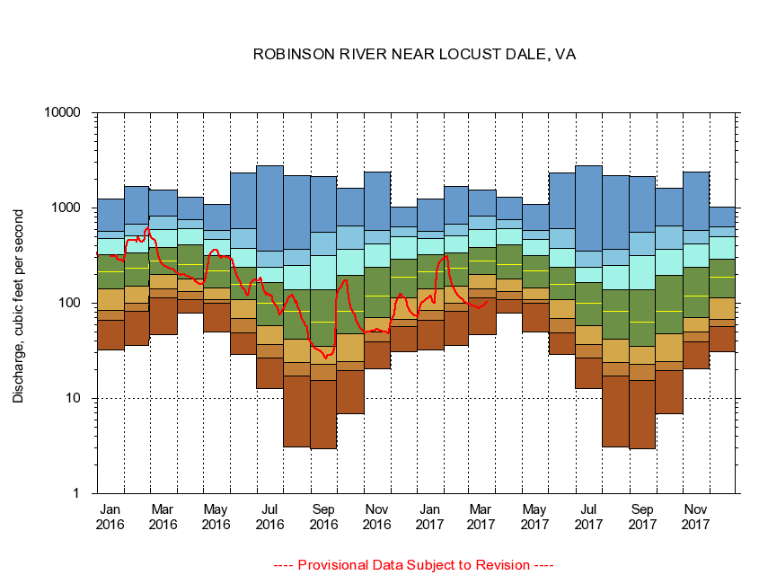
USGS - science for a changing world
Virginia DEQ

Virginia Water Science Center

 
  Duration Plot and Table of 14-Day Average Streamflow
 
01666500 ROBINSON RIVER NEAR LOCUST DALE, VA
LOCATION.--Latitude 38°19'30", Longitude 78°05'45", North American Datum of 1927,
                    Madison County, VA, Hydrologic Unit 02080103.
DRAINAGE AREA.--179 square miles.
PERIOD OF RECORD.--July 1943 to current year. Prior to October 1965, published as Robertson River near Locust Dale.
DURATION STATISTIC COMPUTATION PERIOD.--All data through September 2007.
REGULATION.--Low flow regulated by powerplant about 11 miles above station and at mill about 14 miles above station in prior years.
GAGE OPERATION.--Virginia Department of Environmental Quality - Water Division.

     Duration Plot with 14-Day Average Streamflow Conditions
Provisional Data Subject to Revision
01666500 plot. 
ROBINSON RIVER NEAR LOCUST DALE, VA
Provisional Data Subject to Revision


The current 14-day running-average value for 08/28/2008 is 29.07 cubic feet per second.

  explanation   Percentile Description Duration Plot Description 28 Day 14 Day 7 Day Daily


      Duration Table of 14-Day Average Streamflow
           
Flow values in cubic feet per second


                01666500     ROBINSON RIVER NEAR LOCUST DALE, VA

   Minimum daily flow
   5th percentile
 
   10th percentile
 
   25th percentile
 
 
   Median
 
 
   75th percentile


   90th percentile


   95th percentile


   Maximum daily flow
         
Years of record
January
32.1
62.8
91.0
143
216
331
476
581
1,230
 
64
February
35.9
81.4
104
157
236
338
520
686
1,670
 
64
March
46.7
118
146
200
277
379
583
796
1,560
 
64
April
79.5
109
131
177
253
420
616
745
1,290
 
64
May
50.2
98.9
107
143
213
305
429
542
1,090
 
64
June
29.1
47.8
65.0
105
156
234
379
596
2,330
 
64
July
12.7
25.8
34.2
56.1
100
166
246
384
2,750
 
64
August
3.07
15.6
22.6
42.1
88.6
148
262
393
2,180
 
64
September
2.94
15.8
22.6
36.0
68.0
146
329
591
2,120
 
65
October
6.89
20.0
24.6
47.4
84.5
200
380
744
1,620
 
64
November
20.6
41.1
49.4
70.4
121
253
453
610
2,390
 
64
December
31.2
57.7
68.0
118
184
287
508
655
1,030
 
64


The current 14-day running-average value for 08/28/2008 is 29.07 cubic feet per second.

---- Provisional Data Subject to Revision ----

Accessibility FOIA Privacy Policies and Notices

Take Pride in America logo USA.gov logo U.S. Department of the Interior | U.S. Geological Survey
URL: http://va.water.usgs.gov/duration_plots/htm_14/dp01666500.htm
Page Contact Information: Virginia WSC Webmaster
Page Last Modified: 8/6/2008