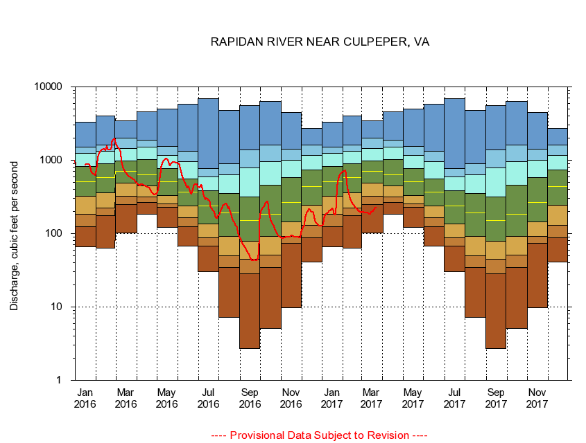
USGS - science for a changing world
Virginia DEQ

Virginia Water Science Center

 
  Duration Plot and Table of 14-Day Average Streamflow
 
01667500 RAPIDAN RIVER NEAR CULPEPER, VA
LOCATION.--Latitude 38°21'01", Longitude 77°58'31", North American Datum of 1927,
                    Culpeper County, VA, Hydrologic Unit 02080103.
DRAINAGE AREA.--468 square miles.
PERIOD OF RECORD.--October 1930 to current year. Monthly discharge only for some periods, published in WSP 1302.
DURATION STATISTIC COMPUTATION PERIOD.--All data through September 2015.
REGULATION.--Low-water flow regulated by operation of mill prior to 1977, since 1986 by a powerplant. Some diversion during summer months for irrigation.
GAGE OPERATION.--Virginia Department of Environmental Quality - Water Division.

     Duration Plot with 14-Day Average Streamflow Conditions
Provisional Data Subject to Revision
01667500 plot. 
RAPIDAN RIVER NEAR CULPEPER, VA
Provisional Data Subject to Revision


The current 14-day running-average value for 03/22/2017 is 225.43 cubic feet per second.

  explanation   Percentile Description Duration Plot Description 28 Day 14 Day 7 Day Daily


      Duration Table of 14-Day Average Streamflow
           
Flow values in cubic feet per second


                01667500     RAPIDAN RIVER NEAR CULPEPER, VA

   Minimum daily flow
   5th percentile
 
   10th percentile
 
   25th percentile
 
 
   Median
 
 
   75th percentile


   90th percentile


   95th percentile


   Maximum daily flow
         
Years of record
January
66.1
124
185
322
511
819
1,250
1,520
3,270
 
85
February
63.4
177
223
361
581
898
1,320
1,600
3,990
 
85
March
102
249
325
485
703
978
1,450
2,010
3,480
 
85
April
182
268
316
444
636
1,020
1,500
1,890
4,600
 
85
May
122
227
252
328
513
777
1,170
1,560
4,970
 
85
June
67.4
124
164
239
366
558
963
1,330
5,830
 
85
July
30.1
67.3
87.8
135
237
381
588
778
6,900
 
85
August
7.19
34.8
49.7
91.8
191
349
633
890
4,750
 
85
September
2.69
28.3
45.2
78.3
150
313
781
1,380
5,530
 
85
October
5.07
34.2
51.1
92.6
184
460
956
1,620
6,300
 
84
November
9.71
74.4
91.9
146
267
579
992
1,420
4,480
 
85
December
40.9
88.0
130
245
439
741
1,170
1,600
2,700
 
85


The current 14-day running-average value for 03/22/2017 is 225.43 cubic feet per second.

---- Provisional Data Subject to Revision ----

Accessibility FOIA Privacy Policies and Notices

Take Pride in America logo USA.gov logo U.S. Department of the Interior | U.S. Geological Survey
URL: http://va.water.usgs.gov/duration_plots/htm_14/dp01667500.htm
Page Contact Information: Virginia WSC Webmaster
Page Last Modified: 6/19/2016