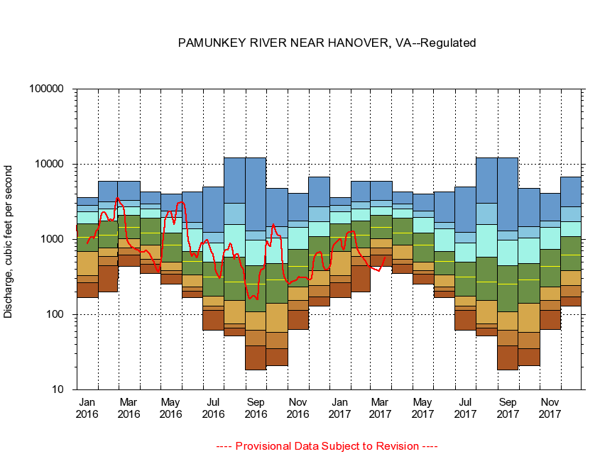
USGS - science for a changing world
Virginia DEQ

Virginia Water Science Center

 
  Duration Plot and Table of 14-Day Average Streamflow
 
01673000 PAMUNKEY RIVER NEAR HANOVER, VA
LOCATION.--Latitude 37°46'03", Longitude 77°19'57", North American Datum of 1927,
                    Hanover County, VA, Hydrologic Unit 02080106.
DRAINAGE AREA.--1,078 square miles.
PERIOD OF RECORD.--October 1941 to current year. Monthly discharge only for some periods, published in WSP 1302.
DURATION STATISTIC COMPUTATION PERIOD.--October 1941 to January 1972.
REGULATION.--Slight regulation from small mill dams upstream and by Lake Anna Power Station on North River since January 1972. Some diversion during summer months for irrigation.
GAGE OPERATION.--U.S. Geological Survey, Virginia Water Science Center.

     Duration Plot with 14-Day Average Streamflow Conditions
Provisional Data Subject to Revision
01673000 plot. 
PAMUNKEY RIVER NEAR HANOVER, VA
Provisional Data Subject to Revision


The current 14-day running-average value for 10/11/2008 is 178.14 cubic feet per second.

  explanation   Percentile Description Duration Plot Description 28 Day 14 Day 7 Day Daily


      Duration Table of 14-Day Average Streamflow
           
Flow values in cubic feet per second


                01673000     PAMUNKEY RIVER NEAR HANOVER, VA

   Minimum daily flow
   5th percentile
 
   10th percentile
 
   25th percentile
 
 
   Median
 
 
   75th percentile


   90th percentile


   95th percentile


   Maximum daily flow
         
Years of record
January
170
268
329
696
1,070
1,630
2,340
2,830
3,620
 
30
February
202
447
591
771
1,150
1,770
2,540
3,180
5,880
 
30
March
440
620
768
1,040
1,450
2,080
2,700
3,290
5,960
 
30
April
356
466
548
836
1,220
1,920
2,570
2,950
4,250
 
30
May
254
349
382
505
840
1,210
1,950
2,380
4,030
 
30
June
169
205
233
337
510
690
1,390
1,700
4,250
 
30
July
62.3
115
130
178
319
501
895
1,240
5,030
 
30
August
51.7
66.0
75.7
157
271
578
1,590
2,980
12,200
 
30
September
18.2
39.6
62.4
109
255
448
972
1,300
12,200
 
30
October
21.0
35.0
57.7
143
290
479
1,030
1,470
4,740
 
30
November
63.2
115
157
235
440
742
1,440
1,750
4,120
 
31
December
130
173
242
387
621
1,100
1,730
2,730
6,770
 
31


The current 14-day running-average value for 10/11/2008 is 178.14 cubic feet per second.

---- Provisional Data Subject to Revision ----

Accessibility FOIA Privacy Policies and Notices

Take Pride in America logo USA.gov logo U.S. Department of the Interior | U.S. Geological Survey
URL: http://va.water.usgs.gov/duration_plots/htm_14/dp01673000.htm
Page Contact Information: Virginia WSC Webmaster
Page Last Modified: 9/19/2008