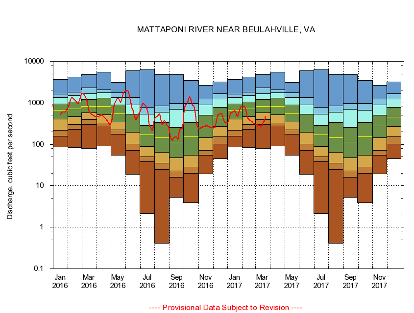
USGS - science for a changing world
Virginia DEQ

Virginia Water Science Center

 
  Duration Plot and Table of 14-Day Average Streamflow
 
01674500 MATTAPONI RIVER NEAR BEULAHVILLE, VA
LOCATION.--Latitude 37°53'16", Longitude 77°09'48", North American Datum of 1927,
                    King William County, VA, Hydrologic Unit 02080105.
DRAINAGE AREA.--602 square miles.
PERIOD OF RECORD.--September 1941 to September 1987, October 1989 to current year.
DURATION STATISTIC COMPUTATION PERIOD.--All data through September 2015.
REGULATION.--Some regulation in the past, during low flows, caused by mill on Po River.
GAGE OPERATION.--U.S. Geological Survey, Virginia Water Science Center.

     Duration Plot with 14-Day Average Streamflow Conditions
Provisional Data Subject to Revision
01674500 plot. 
MATTAPONI RIVER NEAR BEULAHVILLE, VA
Provisional Data Subject to Revision


The current 14-day running-average value for 03/22/2017 is 455.07 cubic feet per second.

  explanation   Percentile Description Duration Plot Description 28 Day 14 Day 7 Day Daily


      Duration Table of 14-Day Average Streamflow
           
Flow values in cubic feet per second


                01674500     MATTAPONI RIVER NEAR BEULAHVILLE, VA

   Minimum daily flow
   5th percentile
 
   10th percentile
 
   25th percentile
 
 
   Median
 
 
   75th percentile


   90th percentile


   95th percentile


   Maximum daily flow
         
Years of record
January
85.7
158
220
405
668
942
1,330
1,620
3,670
 
74
February
84.7
229
302
467
718
1,050
1,510
1,830
4,160
 
74
March
78.9
304
398
573
831
1,190
1,660
2,320
4,850
 
74
April
91.1
274
328
515
823
1,290
1,740
2,090
5,510
 
74
May
54.6
173
223
349
554
890
1,340
1,740
3,070
 
74
June
18.8
70.7
101
196
330
531
898
1,330
5,960
 
74
July
2.16
38.5
50.8
89.3
171
288
534
772
6,280
 
74
August
0.41
25.1
35.4
64.9
145
335
586
853
4,760
 
74
September
5.33
16.2
22.8
47.9
113
254
690
966
4,830
 
74
October
3.87
19.7
28.7
55.0
154
333
656
974
3,460
 
73
November
19.3
53.9
72.0
145
275
509
896
1,240
2,620
 
74
December
45.4
102
153
272
451
787
1,240
1,680
3,230
 
74


The current 14-day running-average value for 03/22/2017 is 455.07 cubic feet per second.

---- Provisional Data Subject to Revision ----

Accessibility FOIA Privacy Policies and Notices

Take Pride in America logo USA.gov logo U.S. Department of the Interior | U.S. Geological Survey
URL: http://va.water.usgs.gov/duration_plots/htm_14/dp01674500.htm
Page Contact Information: Virginia WSC Webmaster
Page Last Modified: 6/19/2016