|
02011500
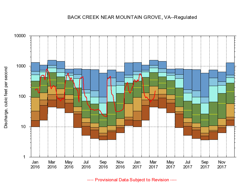
BACK CREEK NEAR MOUNTAIN GROVE, VA
|
Minimum daily flow
|
|
|
5th percentile
|
|
|
|
10th percentile
|
|
|
|
|
25th percentile
|
|
|
|
|
|
Median
|
|
|
|
|
|
|
75th percentile
|
|
|
|
|
|
|
|
90th percentile
|
|
|
|
|
|
|
|
|
95th percentile
|
|
|
|
|
|
|
|
|
|
Maximum daily flow
|
|
|
|
|
|
|
|
|
|
|
|
Years of record
|
January
|
10.0
|
16.2
|
33.0
|
93.4
|
198
|
324
|
519
|
671
|
1,330
|
|
33
|
February
|
16.4
|
51.0
|
76.5
|
132
|
233
|
430
|
641
|
735
|
1,100
|
|
33
|
March
|
44.4
|
77.0
|
117
|
218
|
353
|
619
|
876
|
1,060
|
1,570
|
|
33
|
April
|
41.4
|
90.5
|
120
|
180
|
278
|
445
|
620
|
818
|
1,440
|
|
33
|
May
|
28.9
|
60.4
|
79.8
|
113
|
188
|
337
|
496
|
595
|
805
|
|
33
|
June
|
9.45
|
26.3
|
31.6
|
45.5
|
97.1
|
191
|
391
|
532
|
828
|
|
33
|
July
|
5.19
|
10.4
|
14.0
|
19.7
|
35.1
|
71.2
|
129
|
169
|
780
|
|
33
|
August
|
4.06
|
7.87
|
9.61
|
13.2
|
24.7
|
56.7
|
95.8
|
156
|
766
|
|
33
|
September
|
3.71
|
5.00
|
6.23
|
9.92
|
16.8
|
26.8
|
61.3
|
96.3
|
596
|
|
33
|
October
|
3.74
|
6.90
|
7.64
|
11.0
|
26.2
|
66.5
|
221
|
413
|
752
|
|
32
|
November
|
6.40
|
9.37
|
11.2
|
18.6
|
59.4
|
126
|
231
|
310
|
646
|
|
33
|
December
|
10.8
|
16.9
|
20.9
|
57.5
|
146
|
280
|
421
|
509
|
1,290
|
|
33
|
|
|
|