|
02013000
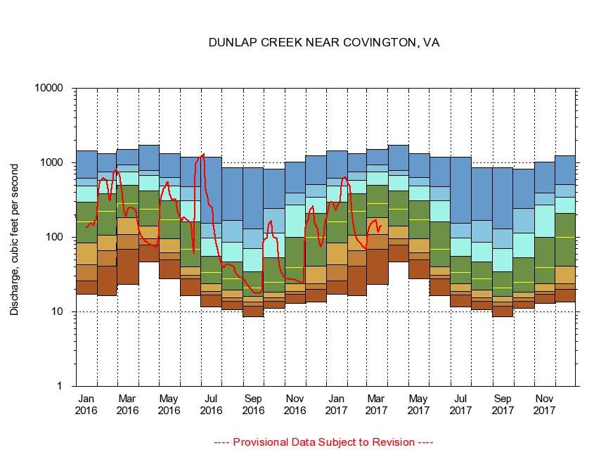
DUNLAP CREEK NEAR COVINGTON, VA
|
Minimum daily flow
|
|
|
5th percentile
|
|
|
|
10th percentile
|
|
|
|
|
25th percentile
|
|
|
|
|
|
Median
|
|
|
|
|
|
|
75th percentile
|
|
|
|
|
|
|
|
90th percentile
|
|
|
|
|
|
|
|
|
95th percentile
|
|
|
|
|
|
|
|
|
|
Maximum daily flow
|
|
|
|
|
|
|
|
|
|
|
|
Years of record
|
January
|
17.1
|
26.2
|
42.8
|
84.6
|
163
|
296
|
492
|
623
|
1,460
|
|
87
|
February
|
16.6
|
40.8
|
66.8
|
106
|
222
|
385
|
578
|
756
|
1,340
|
|
87
|
March
|
23.3
|
68.5
|
109
|
183
|
284
|
497
|
754
|
931
|
1,500
|
|
87
|
April
|
46.8
|
78.5
|
96.7
|
141
|
238
|
418
|
681
|
788
|
1,720
|
|
87
|
May
|
27.9
|
50.3
|
62.1
|
95.8
|
171
|
309
|
489
|
627
|
1,330
|
|
87
|
June
|
16.6
|
27.7
|
31.2
|
40.5
|
69.2
|
161
|
311
|
478
|
1,190
|
|
87
|
July
|
11.7
|
16.8
|
18.6
|
23.9
|
34.1
|
55.1
|
97.4
|
154
|
1,190
|
|
87
|
August
|
10.6
|
14.0
|
15.4
|
19.5
|
27.9
|
46.4
|
86.5
|
170
|
859
|
|
87
|
September
|
8.64
|
12.0
|
13.6
|
16.0
|
21.1
|
34.5
|
70.6
|
130
|
861
|
|
87
|
October
|
11.1
|
13.8
|
15.3
|
18.5
|
25.0
|
52.8
|
115
|
246
|
815
|
|
86
|
November
|
13.0
|
17.2
|
18.9
|
23.9
|
39.3
|
99.0
|
271
|
389
|
1,020
|
|
87
|
December
|
13.5
|
20.0
|
23.9
|
40.8
|
99.6
|
211
|
344
|
509
|
1,230
|
|
87
|
|
|
|