|
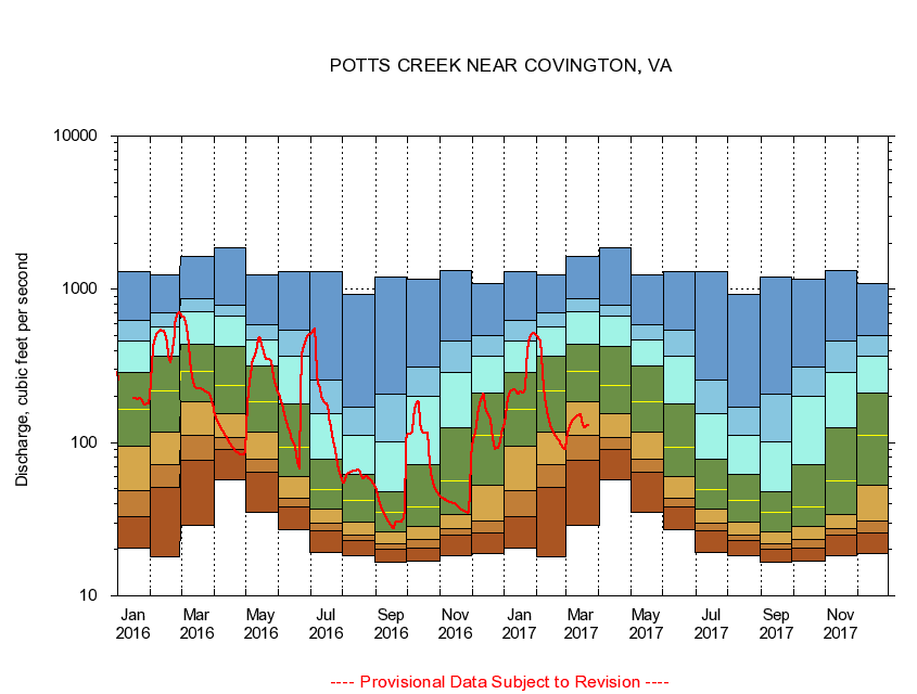
02014000
POTTS CREEK NEAR COVINGTON, VA
|
Minimum daily flow
|
|
|
5th percentile
|
|
|
|
10th percentile
|
|
|
|
|
25th percentile
|
|
|
|
|
|
Median
|
|
|
|
|
|
|
75th percentile
|
|
|
|
|
|
|
|
90th percentile
|
|
|
|
|
|
|
|
|
95th percentile
|
|
|
|
|
|
|
|
|
|
Maximum daily flow
|
|
|
|
|
|
|
|
|
|
|
|
Years of record
|
January
|
20.4
|
32.9
|
48.5
|
94.8
|
166
|
288
|
460
|
630
|
1,310
|
|
78
|
February
|
17.9
|
51.2
|
72.0
|
117
|
219
|
364
|
571
|
701
|
1,250
|
|
78
|
March
|
28.9
|
76.1
|
111
|
185
|
291
|
440
|
714
|
863
|
1,650
|
|
78
|
April
|
56.9
|
90.0
|
108
|
154
|
235
|
422
|
668
|
785
|
1,860
|
|
78
|
May
|
34.9
|
64.0
|
78.1
|
118
|
185
|
317
|
468
|
585
|
1,250
|
|
78
|
June
|
27.2
|
37.8
|
43.4
|
59.7
|
93.2
|
179
|
369
|
542
|
1,300
|
|
78
|
July
|
19.2
|
26.6
|
29.7
|
36.9
|
49.2
|
78.4
|
155
|
255
|
1,310
|
|
78
|
August
|
18.2
|
22.9
|
24.8
|
30.5
|
42.1
|
62.3
|
111
|
170
|
923
|
|
78
|
September
|
16.6
|
20.3
|
22.0
|
26.0
|
35.1
|
47.7
|
101
|
208
|
1,200
|
|
78
|
October
|
16.8
|
20.4
|
23.3
|
28.6
|
38.3
|
72.2
|
199
|
312
|
1,170
|
|
77
|
November
|
18.4
|
24.7
|
27.5
|
34.2
|
56.0
|
125
|
289
|
462
|
1,320
|
|
78
|
December
|
18.9
|
25.6
|
30.6
|
52.8
|
112
|
209
|
369
|
497
|
1,090
|
|
78
|
|
|
|