|
02015700
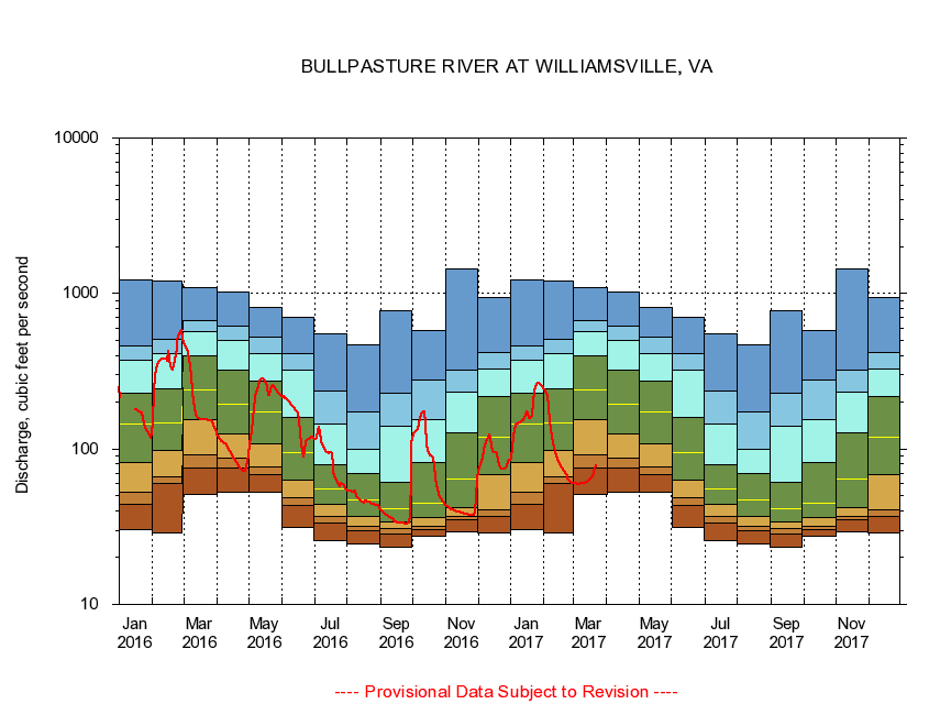
BULLPASTURE RIVER AT WILLIAMSVILLE, VA
|
Minimum daily flow
|
|
|
5th percentile
|
|
|
|
10th percentile
|
|
|
|
|
25th percentile
|
|
|
|
|
|
Median
|
|
|
|
|
|
|
75th percentile
|
|
|
|
|
|
|
|
90th percentile
|
|
|
|
|
|
|
|
|
95th percentile
|
|
|
|
|
|
|
|
|
|
Maximum daily flow
|
|
|
|
|
|
|
|
|
|
|
|
Years of record
|
January
|
30.4
|
43.7
|
52.8
|
81.5
|
144
|
230
|
375
|
460
|
1,220
|
|
55
|
February
|
28.9
|
59.6
|
66.1
|
97.1
|
146
|
242
|
411
|
506
|
1,210
|
|
55
|
March
|
51.3
|
75.2
|
91.8
|
154
|
238
|
397
|
572
|
664
|
1,090
|
|
55
|
April
|
52.4
|
75.5
|
87.2
|
124
|
195
|
319
|
496
|
617
|
1,020
|
|
55
|
May
|
52.4
|
68.4
|
76.2
|
108
|
174
|
273
|
413
|
522
|
807
|
|
55
|
June
|
31.5
|
43.5
|
48.7
|
63.0
|
94.1
|
159
|
321
|
411
|
697
|
|
55
|
July
|
25.7
|
33.4
|
37.1
|
43.7
|
54.9
|
79.4
|
145
|
236
|
554
|
|
55
|
August
|
24.6
|
29.7
|
31.9
|
37.1
|
47.1
|
69.0
|
99.9
|
174
|
468
|
|
55
|
September
|
23.2
|
28.5
|
30.6
|
34.1
|
41.3
|
60.6
|
141
|
227
|
780
|
|
56
|
October
|
27.6
|
30.4
|
31.9
|
36.0
|
45.1
|
81.2
|
154
|
278
|
582
|
|
55
|
November
|
29.1
|
34.8
|
36.6
|
41.9
|
63.8
|
126
|
233
|
320
|
1,440
|
|
55
|
December
|
28.8
|
36.8
|
40.9
|
68.1
|
119
|
218
|
328
|
417
|
946
|
|
55
|
|
|
|