|
02018000
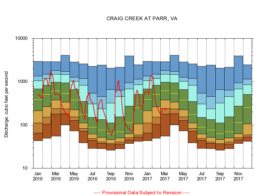
CRAIG CREEK AT PARR, VA
|
Minimum daily flow
|
|
|
5th percentile
|
|
|
|
10th percentile
|
|
|
|
|
25th percentile
|
|
|
|
|
|
Median
|
|
|
|
|
|
|
75th percentile
|
|
|
|
|
|
|
|
90th percentile
|
|
|
|
|
|
|
|
|
95th percentile
|
|
|
|
|
|
|
|
|
|
Maximum daily flow
|
|
|
|
|
|
|
|
|
|
|
|
Years of record
|
January
|
43.6
|
65.0
|
112
|
215
|
388
|
676
|
1,060
|
1,350
|
2,940
|
|
90
|
February
|
49.3
|
105
|
153
|
266
|
505
|
826
|
1,180
|
1,490
|
2,890
|
|
90
|
March
|
54.9
|
179
|
241
|
380
|
612
|
970
|
1,480
|
1,800
|
2,890
|
|
90
|
April
|
101
|
183
|
236
|
340
|
533
|
947
|
1,460
|
1,720
|
4,060
|
|
90
|
May
|
73.0
|
127
|
154
|
226
|
378
|
654
|
1,020
|
1,270
|
2,860
|
|
91
|
June
|
38.9
|
71.5
|
83.8
|
112
|
177
|
348
|
828
|
1,190
|
2,580
|
|
91
|
July
|
29.0
|
44.1
|
48.8
|
62.3
|
89.2
|
149
|
307
|
542
|
2,280
|
|
91
|
August
|
28.6
|
37.7
|
40.9
|
52.2
|
76.2
|
133
|
237
|
451
|
2,440
|
|
91
|
September
|
26.1
|
34.9
|
37.4
|
46.1
|
63.3
|
111
|
324
|
655
|
2,070
|
|
91
|
October
|
28.5
|
36.3
|
40.7
|
50.2
|
69.5
|
154
|
451
|
638
|
2,170
|
|
90
|
November
|
37.4
|
45.6
|
51.4
|
63.0
|
114
|
275
|
682
|
937
|
3,930
|
|
90
|
December
|
41.9
|
52.6
|
59.5
|
107
|
251
|
509
|
859
|
1,140
|
2,480
|
|
90
|
|
|
|