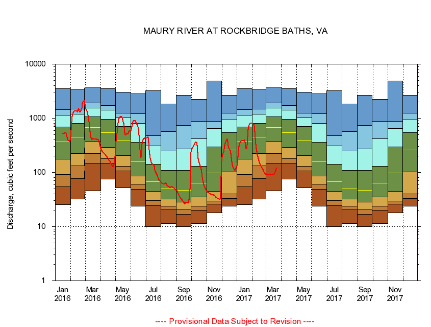
USGS - science for a changing world
Virginia DEQ

Virginia Water Science Center

 
  Duration Plot and Table of 14-Day Average Streamflow
 
02021500 MAURY RIVER AT ROCKBRIDGE BATHS, VA
LOCATION.--Latitude 37°54'26", Longitude 79°25'20", North American Datum of 1927,
                    Rockbridge County, VA, Hydrologic Unit 02080202.
DRAINAGE AREA.--329 square miles.
PERIOD OF RECORD.--October 1928 to current year. Monthly discharge only for some periods, published in WSP 1303. Prior to October 1945, published as North River at Rockbridge Baths.
DURATION STATISTIC COMPUTATION PERIOD.--All data through September 2007.
REGULATION.--Minimal regulation since 1966.
GAGE OPERATION.--U.S. Geological Survey, Virginia Water Science Center.

     Duration Plot with 14-Day Average Streamflow Conditions
Provisional Data Subject to Revision
02021500 plot. 
MAURY RIVER AT ROCKBRIDGE BATHS, VA
Provisional Data Subject to Revision


The current 14-day running-average value for 10/14/2008 is 22.86 cubic feet per second.

  explanation   Percentile Description Duration Plot Description 28 Day 14 Day 7 Day Daily


      Duration Table of 14-Day Average Streamflow
           
Flow values in cubic feet per second


                02021500     MAURY RIVER AT ROCKBRIDGE BATHS, VA

   Minimum daily flow
   5th percentile
 
   10th percentile
 
   25th percentile
 
 
   Median
 
 
   75th percentile


   90th percentile


   95th percentile


   Maximum daily flow
         
Years of record
January
25.5
51.9
90.6
177
375
711
1,150
1,440
3,490
 
79
February
32.2
73.4
129
229
467
820
1,210
1,490
3,420
 
79
March
45.6
153
222
363
665
1,060
1,570
1,900
3,760
 
79
April
74.9
147
174
283
532
963
1,410
1,710
3,500
 
79
May
51.6
104
128
198
374
650
987
1,200
3,050
 
79
June
23.9
47.8
59.7
85.6
157
370
837
1,240
2,820
 
79
July
9.96
24.0
29.7
45.7
69.9
141
319
484
3,210
 
79
August
11.3
20.2
24.1
32.1
50.4
113
283
611
1,840
 
79
September
10.1
17.0
20.7
29.0
47.9
111
274
830
2,640
 
79
October
11.3
19.8
23.5
35.8
64.0
137
494
911
2,210
 
78
November
18.1
25.7
29.5
45.7
99.6
317
674
913
4,840
 
79
December
23.8
31.6
38.2
102
258
518
920
1,210
2,660
 
79


The current 14-day running-average value for 10/14/2008 is 22.86 cubic feet per second.

---- Provisional Data Subject to Revision ----

Accessibility FOIA Privacy Policies and Notices

Take Pride in America logo USA.gov logo U.S. Department of the Interior | U.S. Geological Survey
URL: http://va.water.usgs.gov/duration_plots/htm_14/dp02021500.htm
Page Contact Information: Virginia WSC Webmaster
Page Last Modified: 9/19/2008