|
02024000
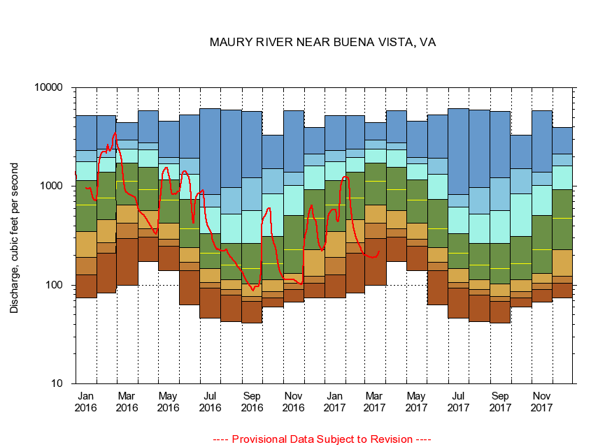
MAURY RIVER NEAR BUENA VISTA, VA
|
Minimum daily flow
|
|
|
5th percentile
|
|
|
|
10th percentile
|
|
|
|
|
25th percentile
|
|
|
|
|
|
Median
|
|
|
|
|
|
|
75th percentile
|
|
|
|
|
|
|
|
90th percentile
|
|
|
|
|
|
|
|
|
95th percentile
|
|
|
|
|
|
|
|
|
|
Maximum daily flow
|
|
|
|
|
|
|
|
|
|
|
|
Years of record
|
January
|
74.6
|
127
|
192
|
346
|
647
|
1,150
|
1,790
|
2,300
|
5,250
|
|
77
|
February
|
82.9
|
209
|
270
|
458
|
766
|
1,390
|
1,970
|
2,370
|
5,190
|
|
77
|
March
|
99.4
|
297
|
427
|
652
|
1,120
|
1,720
|
2,390
|
2,940
|
4,400
|
|
77
|
April
|
174
|
305
|
373
|
569
|
929
|
1,560
|
2,340
|
2,760
|
5,800
|
|
77
|
May
|
140
|
248
|
291
|
423
|
728
|
1,160
|
1,700
|
1,950
|
4,570
|
|
77
|
June
|
63.4
|
141
|
170
|
241
|
373
|
738
|
1,330
|
1,930
|
5,290
|
|
77
|
July
|
46.6
|
93.2
|
106
|
147
|
211
|
331
|
613
|
829
|
6,130
|
|
77
|
August
|
42.4
|
78.9
|
89.9
|
113
|
159
|
264
|
520
|
975
|
5,960
|
|
77
|
September
|
41.6
|
68.0
|
77.2
|
102
|
146
|
263
|
567
|
1,230
|
5,760
|
|
77
|
October
|
60.4
|
74.1
|
85.3
|
113
|
164
|
310
|
837
|
1,510
|
3,310
|
|
76
|
November
|
66.8
|
90.2
|
105
|
132
|
227
|
506
|
1,020
|
1,390
|
5,850
|
|
77
|
December
|
74.5
|
105
|
122
|
229
|
475
|
926
|
1,620
|
2,140
|
3,960
|
|
77
|
|
|
|