|
02027000
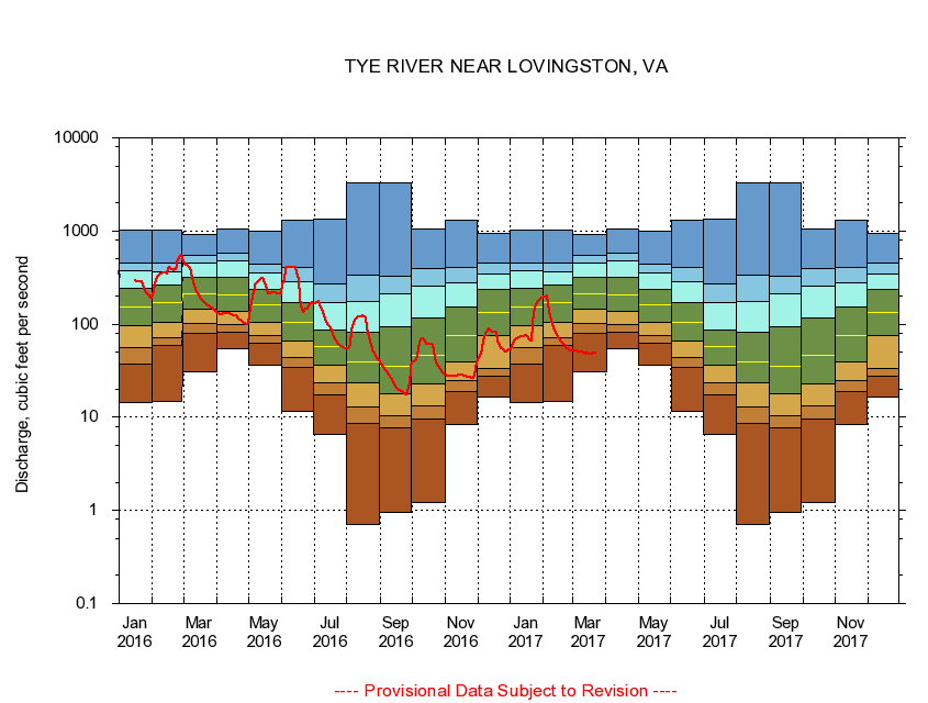
TYE RIVER NEAR LOVINGSTON, VA
|
Minimum daily flow
|
|
|
5th percentile
|
|
|
|
10th percentile
|
|
|
|
|
25th percentile
|
|
|
|
|
|
Median
|
|
|
|
|
|
|
75th percentile
|
|
|
|
|
|
|
|
90th percentile
|
|
|
|
|
|
|
|
|
95th percentile
|
|
|
|
|
|
|
|
|
|
Maximum daily flow
|
|
|
|
|
|
|
|
|
|
|
|
Years of record
|
January
|
14.3
|
37.6
|
55.6
|
95.9
|
151
|
244
|
371
|
447
|
1,030
|
|
77
|
February
|
14.7
|
59.8
|
71.4
|
105
|
169
|
261
|
363
|
458
|
1,020
|
|
77
|
March
|
30.4
|
79.6
|
101
|
146
|
210
|
315
|
453
|
540
|
906
|
|
77
|
April
|
54.8
|
80.8
|
100
|
137
|
207
|
317
|
481
|
574
|
1,050
|
|
77
|
May
|
36.7
|
62.9
|
74.9
|
104
|
160
|
237
|
350
|
436
|
987
|
|
77
|
June
|
11.5
|
34.5
|
44.4
|
65.1
|
104
|
168
|
283
|
411
|
1,320
|
|
77
|
July
|
6.57
|
17.6
|
23.4
|
36.3
|
57.1
|
87.4
|
168
|
272
|
1,330
|
|
77
|
August
|
0.70
|
8.53
|
12.8
|
23.6
|
39.4
|
82.0
|
174
|
334
|
3,250
|
|
77
|
September
|
0.96
|
7.68
|
10.3
|
17.7
|
35.0
|
94.2
|
213
|
330
|
3,250
|
|
77
|
October
|
1.20
|
9.46
|
13.1
|
22.8
|
46.8
|
116
|
256
|
393
|
1,050
|
|
76
|
November
|
8.44
|
19.0
|
24.9
|
39.7
|
75.4
|
153
|
278
|
407
|
1,320
|
|
77
|
December
|
16.3
|
27.7
|
33.2
|
74.6
|
135
|
236
|
344
|
456
|
950
|
|
77
|
|
|
|