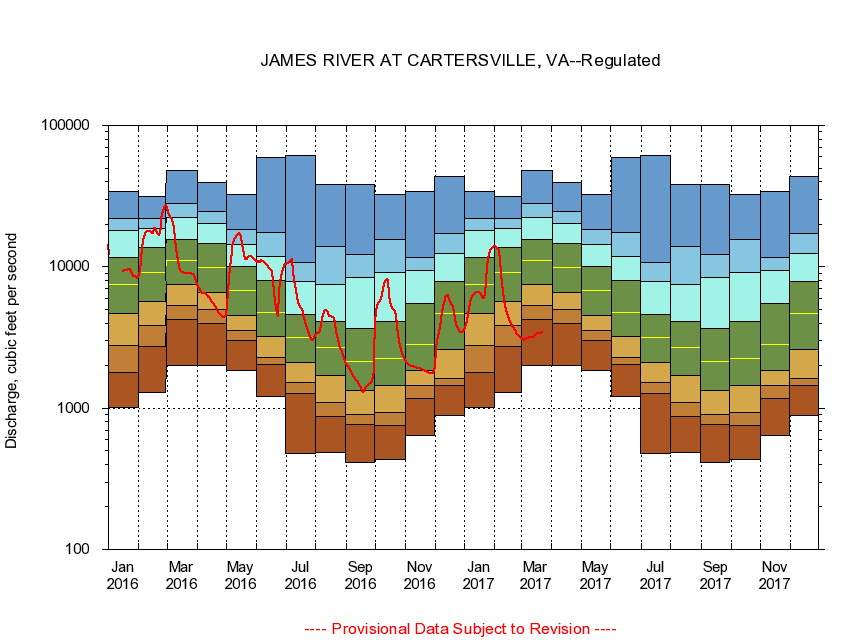
USGS - science for a changing world
Virginia DEQ

Virginia Water Science Center

 
  Duration Plot and Table of 14-Day Average Streamflow
 
02035000 JAMES RIVER AT CARTERSVILLE, VA
LOCATION.--Latitude 37°40'15", Longitude 78°05'10", North American Datum of 1927,
                    Goochland County, VA, Hydrologic Unit 02080205.
DRAINAGE AREA.--6,252 square miles.
PERIOD OF RECORD.--October 1898 to current year. Monthly discharge only for some periods, published in WSP 1303.
DURATION STATISTIC COMPUTATION PERIOD.--October 1898 to June 1982.
REGULATION.--Considerable regulation from Moomaw Lake, 230 miles upstream, as well as moderate diurnal fluctuation by powerplants above Lynchburg, 100 miles upstream. Flow augmented by summertime releases since 1982.
GAGE OPERATION.--U.S. Geological Survey, Virginia Water Science Center.

     Duration Plot with 14-Day Average Streamflow Conditions
Provisional Data Subject to Revision
02035000 plot. 
JAMES RIVER AT CARTERSVILLE, VA
Provisional Data Subject to Revision


The current 14-day running-average value for 03/22/2017 is 3431.43 cubic feet per second.

  explanation   Percentile Description Duration Plot Description 28 Day 14 Day 7 Day Daily


      Duration Table of 14-Day Average Streamflow
           
Flow values in cubic feet per second


                02035000     JAMES RIVER AT CARTERSVILLE, VA

   Minimum daily flow
   5th percentile
 
   10th percentile
 
   25th percentile
 
 
   Median
 
 
   75th percentile


   90th percentile


   95th percentile


   Maximum daily flow
         
Years of record
January
1,010
1,780
2,780
4,640
7,480
11,700
18,000
21,800
34,000
 
83
February
1,300
2,710
3,850
5,720
9,080
13,800
18,800
22,100
31,700
 
84
March
2,020
4,240
5,340
7,460
11,000
15,700
22,500
27,900
48,400
 
84
April
2,020
3,950
4,950
6,630
9,820
14,600
20,300
24,600
39,800
 
84
May
1,850
3,020
3,540
4,540
6,790
10,100
14,300
18,500
32,400
 
84
June
1,210
2,030
2,280
3,220
4,740
7,950
11,900
17,500
59,800
 
83
July
480
1,260
1,520
2,120
3,140
4,590
7,880
10,700
61,300
 
83
August
487
874
1,100
1,700
2,690
4,100
7,560
13,900
38,200
 
83
September
414
770
902
1,330
2,130
3,640
8,450
12,200
38,100
 
83
October
435
752
936
1,440
2,240
4,110
9,050
15,700
32,600
 
83
November
639
1,180
1,440
1,850
2,840
5,470
9,350
11,600
33,900
 
83
December
889
1,440
1,620
2,580
4,670
7,850
12,500
17,200
43,300
 
83


The current 14-day running-average value for 03/22/2017 is 3431.43 cubic feet per second.

---- Provisional Data Subject to Revision ----

Accessibility FOIA Privacy Policies and Notices

Take Pride in America logo USA.gov logo U.S. Department of the Interior | U.S. Geological Survey
URL: http://va.water.usgs.gov/duration_plots/htm_14/dp02035000.htm
Page Contact Information: Virginia WSC Webmaster
Page Last Modified: 6/19/2016