|
02040000
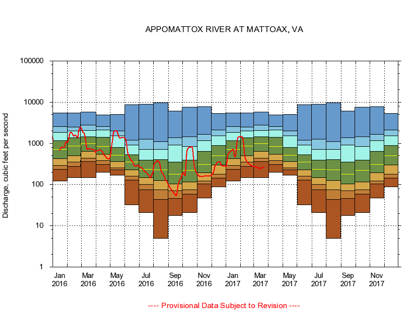
APPOMATTOX RIVER AT MATTOAX, VA
|
Minimum daily flow
|
|
|
5th percentile
|
|
|
|
10th percentile
|
|
|
|
|
25th percentile
|
|
|
|
|
|
Median
|
|
|
|
|
|
|
75th percentile
|
|
|
|
|
|
|
|
90th percentile
|
|
|
|
|
|
|
|
|
95th percentile
|
|
|
|
|
|
|
|
|
|
Maximum daily flow
|
|
|
|
|
|
|
|
|
|
|
|
Years of record
|
January
|
123
|
236
|
292
|
430
|
711
|
1,180
|
1,870
|
2,550
|
5,410
|
|
89
|
February
|
148
|
274
|
357
|
505
|
869
|
1,360
|
2,000
|
2,490
|
5,520
|
|
89
|
March
|
147
|
362
|
437
|
634
|
978
|
1,440
|
2,050
|
2,780
|
5,740
|
|
89
|
April
|
201
|
311
|
379
|
550
|
845
|
1,400
|
2,120
|
2,570
|
4,970
|
|
89
|
May
|
168
|
229
|
257
|
365
|
521
|
800
|
1,530
|
2,030
|
5,020
|
|
90
|
June
|
31.9
|
129
|
159
|
230
|
354
|
534
|
912
|
1,190
|
8,790
|
|
90
|
July
|
21.2
|
75.5
|
101
|
148
|
232
|
391
|
711
|
1,250
|
8,930
|
|
90
|
August
|
4.94
|
43.6
|
74.3
|
127
|
229
|
409
|
710
|
1,110
|
9,630
|
|
90
|
September
|
18.0
|
45.8
|
71.2
|
105
|
181
|
351
|
912
|
1,380
|
6,030
|
|
90
|
October
|
20.9
|
58.9
|
75.1
|
116
|
220
|
391
|
842
|
1,430
|
7,550
|
|
89
|
November
|
47.1
|
104
|
123
|
195
|
309
|
635
|
1,170
|
1,670
|
7,850
|
|
89
|
December
|
88.6
|
142
|
181
|
298
|
497
|
876
|
1,510
|
2,110
|
5,350
|
|
89
|
|
|
|