|
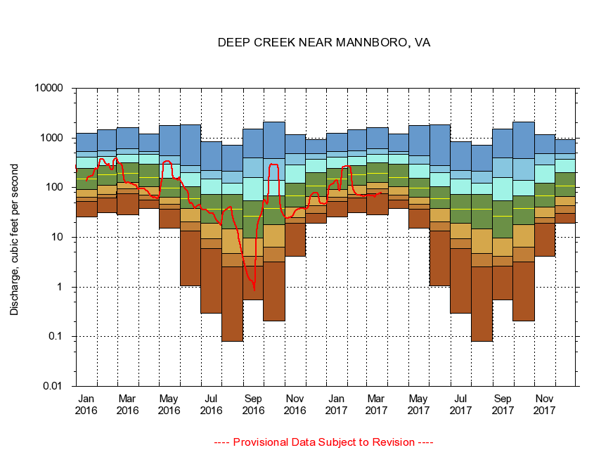
02041000
DEEP CREEK NEAR MANNBORO, VA
|
Minimum daily flow
|
|
|
5th percentile
|
|
|
|
10th percentile
|
|
|
|
|
25th percentile
|
|
|
|
|
|
Median
|
|
|
|
|
|
|
75th percentile
|
|
|
|
|
|
|
|
90th percentile
|
|
|
|
|
|
|
|
|
95th percentile
|
|
|
|
|
|
|
|
|
|
Maximum daily flow
|
|
|
|
|
|
|
|
|
|
|
|
Years of record
|
January
|
25.9
|
52.4
|
63.9
|
90.4
|
148
|
246
|
404
|
533
|
1,230
|
|
69
|
February
|
30.9
|
62.6
|
74.1
|
112
|
180
|
277
|
422
|
558
|
1,470
|
|
69
|
March
|
28.8
|
74.6
|
93.7
|
126
|
196
|
315
|
472
|
606
|
1,600
|
|
69
|
April
|
38.5
|
56.3
|
71.2
|
105
|
160
|
294
|
462
|
535
|
1,210
|
|
69
|
May
|
15.4
|
37.1
|
45.6
|
63.1
|
96.5
|
156
|
299
|
438
|
1,780
|
|
69
|
June
|
1.05
|
13.4
|
20.2
|
37.9
|
60.9
|
105
|
203
|
275
|
1,810
|
|
69
|
July
|
0.30
|
5.92
|
9.29
|
18.9
|
36.9
|
73.1
|
150
|
218
|
836
|
|
69
|
August
|
0.08
|
2.51
|
4.67
|
14.6
|
36.5
|
73.9
|
122
|
212
|
718
|
|
69
|
September
|
0.55
|
2.64
|
4.17
|
9.71
|
26.3
|
54.4
|
162
|
402
|
1,520
|
|
69
|
October
|
0.21
|
3.21
|
6.28
|
18.1
|
38.0
|
67.5
|
139
|
383
|
2,080
|
|
68
|
November
|
4.13
|
18.9
|
24.5
|
40.1
|
67.5
|
123
|
283
|
489
|
1,160
|
|
69
|
December
|
18.9
|
30.2
|
42.7
|
65.2
|
107
|
199
|
371
|
480
|
913
|
|
69
|
|
|
|