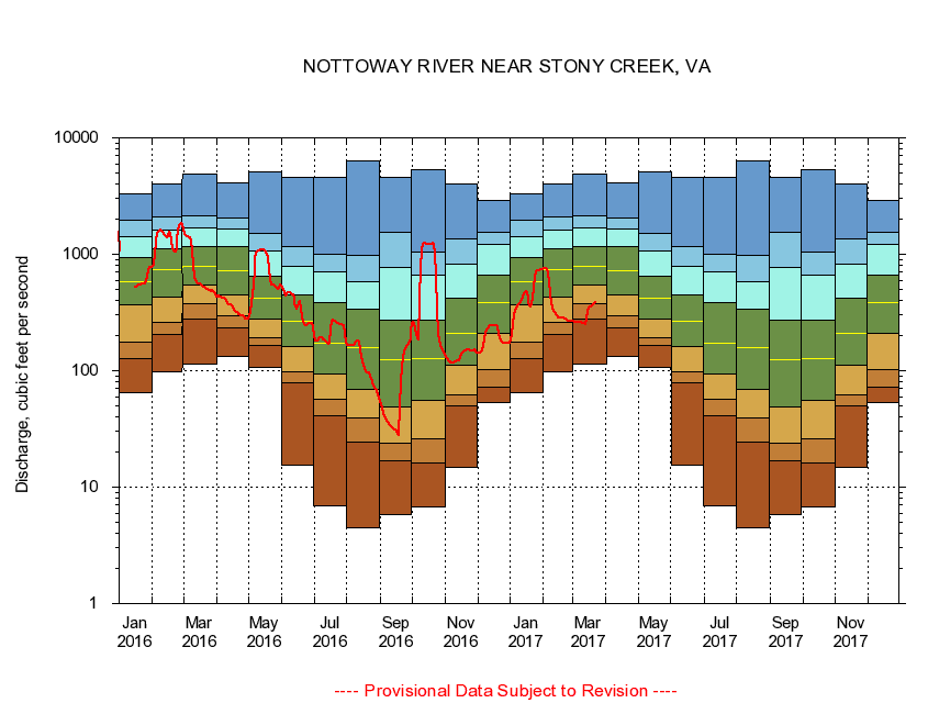
USGS - science for a changing world
Virginia DEQ

Virginia Water Science Center

 
  Duration Plot and Table of 14-Day Average Streamflow
 
02045500 NOTTOWAY RIVER NEAR STONY CREEK, VA
LOCATION.--Latitude 36°54'00", Longitude 77°24'00", North American Datum of 1927,
                    Sussex County, VA, Hydrologic Unit 03010201.
DRAINAGE AREA.--577 square miles.
PERIOD OF RECORD.--October 1929 to current year. Monthly discharge only for some periods, published in WSP 1303.
DURATION STATISTIC COMPUTATION PERIOD.--All data through September 2015.
REGULATION.--Some diversion during summer months for irrigation, minimal diurnal fluctuation caused by mill.
GAGE OPERATION.--Virginia Department of Environmental Quality - Water Division.

     Duration Plot with 14-Day Average Streamflow Conditions
Provisional Data Subject to Revision
02045500 plot. 
NOTTOWAY RIVER NEAR STONY CREEK, VA
Provisional Data Subject to Revision


The current 14-day running-average value for 03/22/2017 is 384.36 cubic feet per second.

  explanation   Percentile Description Duration Plot Description 28 Day 14 Day 7 Day Daily


      Duration Table of 14-Day Average Streamflow
           
Flow values in cubic feet per second


                02045500     NOTTOWAY RIVER NEAR STONY CREEK, VA

   Minimum daily flow
   5th percentile
 
   10th percentile
 
   25th percentile
 
 
   Median
 
 
   75th percentile


   90th percentile


   95th percentile


   Maximum daily flow
         
Years of record
January
64.8
126
175
366
586
931
1,430
1,940
3,300
 
85
February
98.9
205
262
429
743
1,120
1,610
2,110
4,030
 
85
March
113
276
373
546
795
1,160
1,670
2,160
4,890
 
85
April
132
231
295
446
723
1,160
1,640
2,040
4,110
 
85
May
106
164
191
278
421
642
1,060
1,520
5,090
 
85
June
15.3
77.9
98.4
162
266
443
779
1,170
4,540
 
85
July
6.88
41.4
56.8
93.3
171
383
713
993
4,550
 
85
August
4.45
24.6
39.1
69.6
158
338
576
975
6,370
 
85
September
5.76
16.9
24.1
49.3
125
274
766
1,560
4,540
 
85
October
6.78
16.3
25.9
55.6
128
273
664
1,050
5,290
 
84
November
14.9
50.3
61.5
111
211
419
826
1,360
3,980
 
85
December
52.7
72.8
103
208
387
663
1,210
1,540
2,890
 
85


The current 14-day running-average value for 03/22/2017 is 384.36 cubic feet per second.

---- Provisional Data Subject to Revision ----

Accessibility FOIA Privacy Policies and Notices

Take Pride in America logo USA.gov logo U.S. Department of the Interior | U.S. Geological Survey
URL: http://va.water.usgs.gov/duration_plots/htm_14/dp02045500.htm
Page Contact Information: Virginia WSC Webmaster
Page Last Modified: 6/19/2016