|
02047500
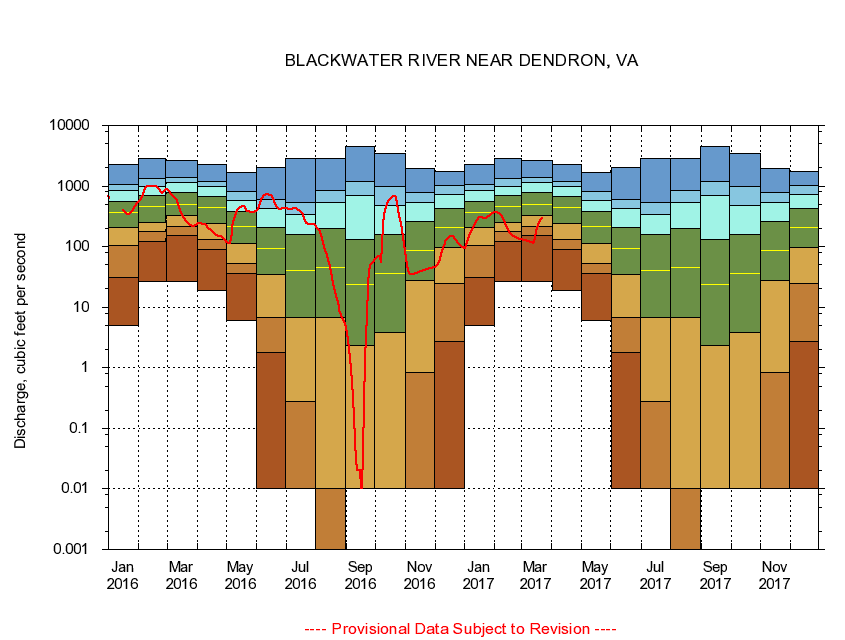
BLACKWATER RIVER NEAR DENDRON, VA
|
Minimum daily flow
|
|
|
5th percentile
|
|
|
|
10th percentile
|
|
|
|
|
25th percentile
|
|
|
|
|
|
Median
|
|
|
|
|
|
|
75th percentile
|
|
|
|
|
|
|
|
90th percentile
|
|
|
|
|
|
|
|
|
95th percentile
|
|
|
|
|
|
|
|
|
|
Maximum daily flow
|
|
|
|
|
|
|
|
|
|
|
|
Years of record
|
January
|
4.98
|
30.8
|
106
|
211
|
366
|
566
|
853
|
1,080
|
2,260
|
|
72
|
February
|
26.5
|
122
|
177
|
250
|
456
|
686
|
966
|
1,310
|
2,840
|
|
72
|
March
|
26.6
|
152
|
216
|
323
|
495
|
780
|
1,150
|
1,360
|
2,600
|
|
72
|
April
|
19.1
|
89.5
|
133
|
244
|
436
|
684
|
974
|
1,170
|
2,290
|
|
72
|
May
|
6.14
|
35.6
|
52.7
|
113
|
215
|
374
|
586
|
828
|
1,670
|
|
72
|
June
|
0.00
|
1.82
|
6.75
|
34.2
|
92.2
|
210
|
432
|
604
|
2,010
|
|
72
|
July
|
0.00
|
0.00
|
0.28
|
6.71
|
40.4
|
157
|
345
|
530
|
2,860
|
|
72
|
August
|
0.00
|
0.00
|
0.00
|
6.88
|
45.1
|
197
|
535
|
844
|
2,870
|
|
72
|
September
|
0.00
|
0.00
|
0.00
|
2.31
|
23.4
|
130
|
698
|
1,200
|
4,490
|
|
73
|
October
|
0.00
|
0.00
|
0.00
|
3.79
|
36.4
|
160
|
479
|
970
|
3,460
|
|
72
|
November
|
0.00
|
0.00
|
0.83
|
27.6
|
87.8
|
257
|
528
|
791
|
1,980
|
|
73
|
December
|
0.00
|
2.67
|
25.0
|
97.4
|
209
|
429
|
713
|
1,010
|
1,750
|
|
73
|
|
|
|