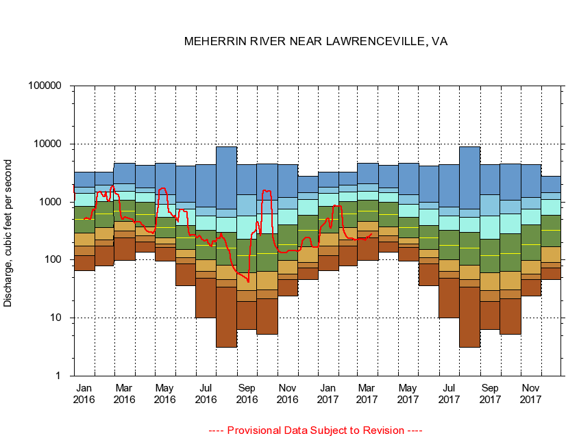
USGS - science for a changing world
Virginia DEQ

Virginia Water Science Center

 
  Duration Plot and Table of 14-Day Average Streamflow
 
02051500 MEHERRIN RIVER NEAR LAWRENCEVILLE, VA
LOCATION.--Latitude 36°43'00", Longitude 77°49'55", North American Datum of 1927,
                    Brunswick County, VA, Hydrologic Unit 03010204.
DRAINAGE AREA.--552 square miles.
PERIOD OF RECORD.--October 1928 to current year. Monthly discharge only for some periods, published in WSP 1303.
DURATION STATISTIC COMPUTATION PERIOD.--All data through September 2015.
REGULATION.--No known regulation.
GAGE OPERATION.--U.S. Geological Survey, Virginia Water Science Center.

     Duration Plot with 14-Day Average Streamflow Conditions
Provisional Data Subject to Revision
02051500 plot. 
MEHERRIN RIVER NEAR LAWRENCEVILLE, VA
Provisional Data Subject to Revision


The current 14-day running-average value for 03/22/2017 is 272.71 cubic feet per second.

  explanation   Percentile Description Duration Plot Description 28 Day 14 Day 7 Day Daily


      Duration Table of 14-Day Average Streamflow
           
Flow values in cubic feet per second


                02051500     MEHERRIN RIVER NEAR LAWRENCEVILLE, VA

   Minimum daily flow
   5th percentile
 
   10th percentile
 
   25th percentile
 
 
   Median
 
 
   75th percentile


   90th percentile


   95th percentile


   Maximum daily flow
         
Years of record
January
66.3
119
173
292
500
842
1,390
1,820
3,300
 
86
February
80.1
174
222
360
630
1,030
1,500
1,950
3,270
 
87
March
97.2
244
317
464
689
1,060
1,530
2,060
4,710
 
87
April
137
204
259
377
611
1,000
1,460
1,770
4,240
 
87
May
97.0
167
191
242
367
542
923
1,340
4,590
 
87
June
35.8
86.9
111
152
238
394
759
981
4,200
 
87
July
10.0
48.1
64.3
99.8
179
327
568
812
4,370
 
87
August
3.12
34.1
46.0
81.4
159
300
550
757
8,890
 
87
September
6.31
19.3
30.1
59.6
118
226
572
1,330
4,430
 
87
October
5.20
21.5
30.6
64.3
128
283
620
1,070
4,580
 
86
November
23.9
45.8
56.9
97.5
186
400
757
1,210
4,410
 
86
December
46.3
72.7
91.6
170
326
596
1,100
1,440
2,750
 
86


The current 14-day running-average value for 03/22/2017 is 272.71 cubic feet per second.

---- Provisional Data Subject to Revision ----

Accessibility FOIA Privacy Policies and Notices

Take Pride in America logo USA.gov logo U.S. Department of the Interior | U.S. Geological Survey
URL: http://va.water.usgs.gov/duration_plots/htm_14/dp02051500.htm
Page Contact Information: Virginia WSC Webmaster
Page Last Modified: 6/19/2016