|
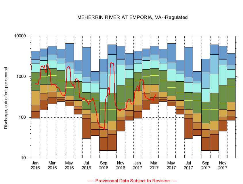
02052000
MEHERRIN RIVER AT EMPORIA, VA
|
Minimum daily flow
|
|
|
5th percentile
|
|
|
|
10th percentile
|
|
|
|
|
25th percentile
|
|
|
|
|
|
Median
|
|
|
|
|
|
|
75th percentile
|
|
|
|
|
|
|
|
90th percentile
|
|
|
|
|
|
|
|
|
95th percentile
|
|
|
|
|
|
|
|
|
|
Maximum daily flow
|
|
|
|
|
|
|
|
|
|
|
|
Years of record
|
January
|
94.9
|
141
|
203
|
453
|
787
|
1,280
|
2,100
|
2,630
|
4,280
|
|
21
|
February
|
151
|
266
|
389
|
634
|
1,030
|
1,500
|
2,490
|
3,040
|
4,880
|
|
21
|
March
|
213
|
312
|
426
|
639
|
1,080
|
1,580
|
2,530
|
3,390
|
5,700
|
|
21
|
April
|
245
|
276
|
307
|
426
|
833
|
1,420
|
2,070
|
2,840
|
4,830
|
|
20
|
May
|
191
|
238
|
261
|
338
|
540
|
783
|
1,530
|
2,260
|
6,600
|
|
20
|
June
|
119
|
158
|
189
|
260
|
399
|
761
|
1,190
|
1,370
|
2,590
|
|
20
|
July
|
30.5
|
92.5
|
119
|
157
|
262
|
410
|
709
|
971
|
5,320
|
|
20
|
August
|
35.4
|
49.9
|
75.6
|
128
|
253
|
407
|
696
|
791
|
1,350
|
|
20
|
September
|
15.3
|
31.9
|
50.1
|
71.4
|
155
|
238
|
514
|
1,310
|
2,740
|
|
20
|
October
|
15.3
|
38.0
|
49.1
|
81.8
|
156
|
399
|
1,170
|
3,500
|
6,120
|
|
20
|
November
|
45.8
|
85.1
|
103
|
157
|
224
|
620
|
1,920
|
2,690
|
5,640
|
|
20
|
December
|
84.2
|
108
|
147
|
241
|
555
|
899
|
1,500
|
1,920
|
3,790
|
|
21
|
|
|
|