|
02054530
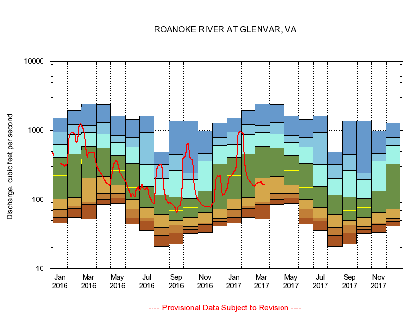
ROANOKE RIVER AT GLENVAR, VA
|
Minimum daily flow
|
|
|
5th percentile
|
|
|
|
10th percentile
|
|
|
|
|
25th percentile
|
|
|
|
|
|
Median
|
|
|
|
|
|
|
75th percentile
|
|
|
|
|
|
|
|
90th percentile
|
|
|
|
|
|
|
|
|
95th percentile
|
|
|
|
|
|
|
|
|
|
Maximum daily flow
|
|
|
|
|
|
|
|
|
|
|
|
Years of record
|
January
|
46.3
|
54.9
|
72.3
|
103
|
223
|
404
|
625
|
952
|
1,520
|
|
24
|
February
|
55.1
|
73.9
|
79.9
|
108
|
237
|
461
|
870
|
1,230
|
1,950
|
|
24
|
March
|
53.1
|
84.0
|
92.2
|
208
|
387
|
588
|
947
|
1,190
|
2,410
|
|
24
|
April
|
84.1
|
101
|
123
|
218
|
328
|
555
|
892
|
1,300
|
2,380
|
|
24
|
May
|
87.9
|
106
|
123
|
162
|
265
|
438
|
672
|
846
|
1,600
|
|
24
|
June
|
44.1
|
54.1
|
73.3
|
101
|
150
|
333
|
576
|
783
|
1,450
|
|
24
|
July
|
35.5
|
49.6
|
54.6
|
76.7
|
102
|
154
|
321
|
942
|
1,620
|
|
24
|
August
|
20.8
|
30.1
|
39.5
|
61.4
|
80.4
|
118
|
203
|
324
|
488
|
|
24
|
September
|
22.9
|
32.8
|
42.9
|
50.5
|
69.6
|
110
|
266
|
456
|
1,360
|
|
24
|
October
|
32.4
|
36.7
|
40.9
|
55.5
|
76.7
|
105
|
195
|
244
|
1,370
|
|
23
|
November
|
33.6
|
43.3
|
46.6
|
65.3
|
82.6
|
133
|
359
|
464
|
990
|
|
23
|
December
|
41.3
|
48.7
|
53.4
|
73.4
|
146
|
326
|
610
|
787
|
1,280
|
|
23
|
|
|
|