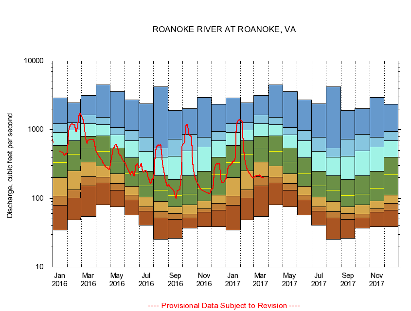
USGS - science for a changing world
Virginia DEQ

Virginia Water Science Center

 
  Duration Plot and Table of 14-Day Average Streamflow
 
02055000 ROANOKE RIVER AT ROANOKE, VA
LOCATION.--Latitude 37°15'30", Longitude 79°56'20", North American Datum of 1927,
                    Roanoke City, VA, Hydrologic Unit 03010101.
DRAINAGE AREA.--384 square miles.
PERIOD OF RECORD.--February 1899 to current year. Monthly discharge only for some periods, published in WSP 1303. Records for July 1896 to January 1899 published in WSP 11, 15, 27, and 20th Annual Report, Part 4, are unreliable, due to doubtful gage-height record, and should not be used.
DURATION STATISTIC COMPUTATION PERIOD.--All data through September 2015.
REGULATION.--Prior to 1949, diurnal fluctuation caused by powerplants. After 1994, withdrawal of 11.1 cfs.
GAGE OPERATION.--U.S. Geological Survey, Virginia Water Science Center.

     Duration Plot with 14-Day Average Streamflow Conditions
Provisional Data Subject to Revision
02055000 plot. 
ROANOKE RIVER AT ROANOKE, VA
Provisional Data Subject to Revision


The current 14-day running-average value for 03/22/2017 is 199.14 cubic feet per second.

  explanation   Percentile Description Duration Plot Description 28 Day 14 Day 7 Day Daily


      Duration Table of 14-Day Average Streamflow
           
Flow values in cubic feet per second


                02055000     ROANOKE RIVER AT ROANOKE, VA

   Minimum daily flow
   5th percentile
 
   10th percentile
 
   25th percentile
 
 
   Median
 
 
   75th percentile


   90th percentile


   95th percentile


   Maximum daily flow
         
Years of record
January
34.3
79.4
108
201
331
588
919
1,220
2,880
 
115
February
48.4
101
133
252
438
691
989
1,270
2,450
 
117
March
54.4
151
206
337
538
803
1,230
1,640
3,160
 
117
April
80.6
168
204
297
481
808
1,180
1,500
4,470
 
117
May
75.1
132
166
228
339
537
844
1,080
3,590
 
117
June
57.6
95.1
112
150
229
392
688
970
2,700
 
117
July
40.8
65.4
75.8
104
152
249
485
781
2,390
 
117
August
25.5
51.6
64.1
89.9
132
215
400
544
4,190
 
117
September
26.1
49.7
60.1
75.9
109
189
413
729
1,890
 
117
October
37.0
51.7
59.1
80.6
115
214
487
851
2,040
 
115
November
38.9
62.7
70.6
91.6
141
249
557
770
2,930
 
115
December
38.9
67.7
84.8
112
222
396
689
942
2,360
 
115


The current 14-day running-average value for 03/22/2017 is 199.14 cubic feet per second.

---- Provisional Data Subject to Revision ----

Accessibility FOIA Privacy Policies and Notices

Take Pride in America logo USA.gov logo U.S. Department of the Interior | U.S. Geological Survey
URL: http://va.water.usgs.gov/duration_plots/htm_14/dp02055000.htm
Page Contact Information: Virginia WSC Webmaster
Page Last Modified: 6/19/2016