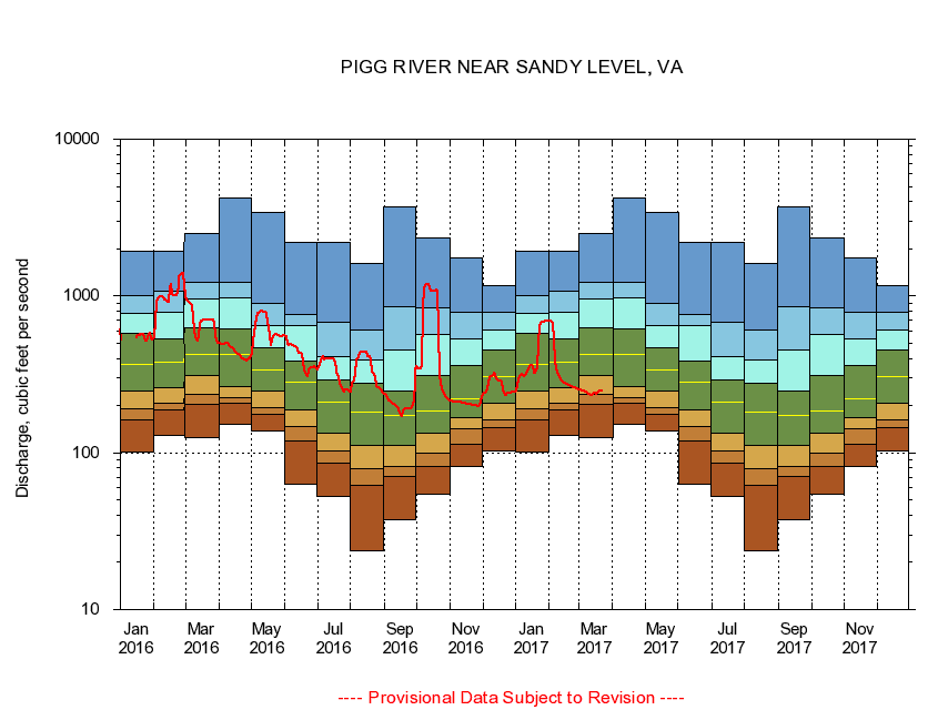
USGS - science for a changing world
Virginia DEQ

Virginia Water Science Center

 
  Duration Plot and Table of 14-Day Average Streamflow
 
02058400 PIGG RIVER NEAR SANDY LEVEL, VA
LOCATION.--Latitude 36°56'45", Longitude 79°31'30", North American Datum of 1927,
                    Pittsylvania County, VA, Hydrologic Unit 03010101.
DRAINAGE AREA.--351 square miles, (measured on USGS topographic maps).
PERIOD OF RECORD.--June 1963 to current year.
DURATION STATISTIC COMPUTATION PERIOD.--All data through September 2015.
REGULATION.--Small amount of diurnal fluctuation; cause unknown.
GAGE OPERATION.--U.S. Geological Survey, Virginia Water Science Center.

     Duration Plot with 14-Day Average Streamflow Conditions
Provisional Data Subject to Revision
02058400 plot. 
PIGG RIVER NEAR SANDY LEVEL, VA
Provisional Data Subject to Revision


The current 14-day running-average value for 03/22/2017 is 248.93 cubic feet per second.

  explanation   Percentile Description Duration Plot Description 28 Day 14 Day 7 Day Daily


      Duration Table of 14-Day Average Streamflow
           
Flow values in cubic feet per second


                02058400     PIGG RIVER NEAR SANDY LEVEL, VA

   Minimum daily flow
   5th percentile
 
   10th percentile
 
   25th percentile
 
 
   Median
 
 
   75th percentile


   90th percentile


   95th percentile


   Maximum daily flow
         
Years of record
January
101
162
191
246
364
575
777
1,000
1,920
 
52
February
129
187
208
260
381
535
789
1,080
1,920
 
52
March
124
203
237
312
422
630
954
1,220
2,490
 
52
April
152
207
223
265
426
614
970
1,230
4,190
 
52
May
138
176
194
248
337
464
651
901
3,400
 
52
June
63.1
119
148
189
283
384
649
762
2,180
 
52
July
52.9
85.7
103
134
212
291
409
676
2,200
 
53
August
23.6
61.6
79.3
111
183
276
394
607
1,610
 
53
September
37.6
70.8
81.2
112
174
249
456
848
3,680
 
53
October
54.6
82.3
98.8
134
184
310
569
834
2,330
 
52
November
81.6
113
142
168
222
363
535
784
1,740
 
52
December
103
144
161
206
306
456
604
783
1,170
 
52


The current 14-day running-average value for 03/22/2017 is 248.93 cubic feet per second.

---- Provisional Data Subject to Revision ----

Accessibility FOIA Privacy Policies and Notices

Take Pride in America logo USA.gov logo U.S. Department of the Interior | U.S. Geological Survey
URL: http://va.water.usgs.gov/duration_plots/htm_14/dp02058400.htm
Page Contact Information: Virginia WSC Webmaster
Page Last Modified: 6/19/2016