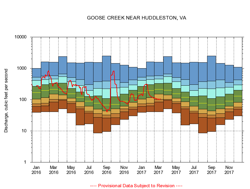
USGS - science for a changing world
Virginia DEQ

Virginia Water Science Center

 
  Duration Plot and Table of 14-Day Average Streamflow
 
02059500 GOOSE CREEK NEAR HUDDLESTON, VA
LOCATION.--Latitude 37°10'23", Longitude 79°31'14", North American Datum of 1927,
                    Bedford County, VA, Hydrologic Unit 03010101.
DRAINAGE AREA.--188 square miles.
PERIOD OF RECORD.--September 1930 to current year.
DURATION STATISTIC COMPUTATION PERIOD.--All data through September 2015.
REGULATION.--Prior to October 1954, diurnal fluctuation at low flow, caused by mill upstream from gage.
GAGE OPERATION.--Virginia Department of Environmental Quality - Water Division.

     Duration Plot with 14-Day Average Streamflow Conditions
Provisional Data Subject to Revision
02059500 plot. 
GOOSE CREEK NEAR HUDDLESTON, VA
Provisional Data Subject to Revision


The current 14-day running-average value for 03/22/2017 is 104.14 cubic feet per second.

  explanation   Percentile Description Duration Plot Description 28 Day 14 Day 7 Day Daily


      Duration Table of 14-Day Average Streamflow
           
Flow values in cubic feet per second


                02059500     GOOSE CREEK NEAR HUDDLESTON, VA

   Minimum daily flow
   5th percentile
 
   10th percentile
 
   25th percentile
 
 
   Median
 
 
   75th percentile


   90th percentile


   95th percentile


   Maximum daily flow
         
Years of record
January
39.6
60.8
73.8
104
168
266
406
521
1,010
 
85
February
41.2
63.3
77.3
116
194
306
435
564
1,610
 
85
March
40.6
83.5
102
151
216
330
453
580
1,570
 
85
April
51.0
95.3
103
141
202
336
548
661
2,380
 
85
May
37.9
76.0
85.6
112
154
230
373
513
1,500
 
85
June
15.6
51.2
59.0
86.1
120
175
285
438
1,490
 
85
July
16.9
37.3
43.2
61.6
90.3
128
195
304
1,590
 
85
August
8.52
26.9
35.9
50.1
77.1
134
228
378
1,560
 
85
September
9.49
25.8
32.6
43.6
67.9
109
222
395
2,510
 
85
October
15.9
26.7
36.4
50.6
71.2
124
239
427
1,460
 
84
November
23.4
40.6
50.6
62.3
89.0
151
251
354
1,270
 
85
December
30.3
49.5
58.5
82.2
131
201
298
427
1,090
 
85


The current 14-day running-average value for 03/22/2017 is 104.14 cubic feet per second.

---- Provisional Data Subject to Revision ----

Accessibility FOIA Privacy Policies and Notices

Take Pride in America logo USA.gov logo U.S. Department of the Interior | U.S. Geological Survey
URL: http://va.water.usgs.gov/duration_plots/htm_14/dp02059500.htm
Page Contact Information: Virginia WSC Webmaster
Page Last Modified: 6/19/2016