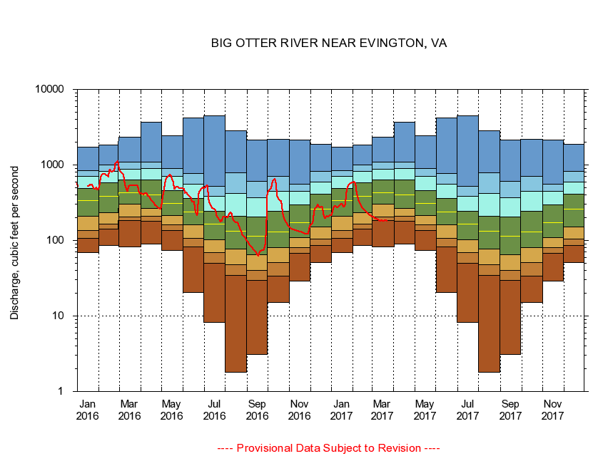
USGS - science for a changing world
Virginia DEQ

Virginia Water Science Center

 
  Duration Plot and Table of 14-Day Average Streamflow
 
02061500 BIG OTTER RIVER NEAR EVINGTON, VA
LOCATION.--Latitude 37°12'30", Longitude 79°18'14", North American Datum of 1927,
                    Campbell County, VA, Hydrologic Unit 03010101
DRAINAGE AREA.--315 square miles.
PERIOD OF RECORD.--October 1936 to current year. Monthly discharge only for some periods, published in WSP 1303. Prior to October 1965, published as Otter River near Evington.
DURATION STATISTIC COMPUTATION PERIOD.--All data through September 2015.
REGULATION.--No known regulation.
GAGE OPERATION.--Virginia Department of Environmental Quality - Water Division.

     Duration Plot with 14-Day Average Streamflow Conditions
Provisional Data Subject to Revision
02061500 plot. 
BIG OTTER RIVER NEAR EVINGTON, VA
Provisional Data Subject to Revision


The current 14-day running-average value for 03/22/2017 is 179.86 cubic feet per second.

  explanation   Percentile Description Duration Plot Description 28 Day 14 Day 7 Day Daily


      Duration Table of 14-Day Average Streamflow
           
Flow values in cubic feet per second


                02061500     BIG OTTER RIVER NEAR EVINGTON, VA

   Minimum daily flow
   5th percentile
 
   10th percentile
 
   25th percentile
 
 
   Median
 
 
   75th percentile


   90th percentile


   95th percentile


   Maximum daily flow
         
Years of record
January
69.1
106
135
208
338
493
713
838
1,740
 
78
February
85.1
142
166
232
384
582
830
1,010
1,840
 
78
March
83.1
182
204
306
425
627
875
1,090
2,310
 
78
April
90.1
179
208
265
401
633
890
1,100
3,720
 
78
May
73.1
136
162
212
312
459
702
888
2,430
 
79
June
20.4
81.6
107
160
239
361
560
772
4,180
 
79
July
8.16
50.1
69.6
103
165
245
382
521
4,430
 
79
August
1.80
34.3
48.2
77.7
134
211
421
782
2,850
 
79
September
3.09
29.8
40.1
64.9
113
203
370
606
2,120
 
79
October
15.0
33.5
50.6
80.4
130
243
448
704
2,190
 
78
November
28.9
68.0
80.2
110
173
297
450
562
2,120
 
78
December
50.7
86.1
104
152
261
411
592
822
1,880
 
78


The current 14-day running-average value for 03/22/2017 is 179.86 cubic feet per second.

---- Provisional Data Subject to Revision ----

Accessibility FOIA Privacy Policies and Notices

Take Pride in America logo USA.gov logo U.S. Department of the Interior | U.S. Geological Survey
URL: http://va.water.usgs.gov/duration_plots/htm_14/dp02061500.htm
Page Contact Information: Virginia WSC Webmaster
Page Last Modified: 6/19/2016