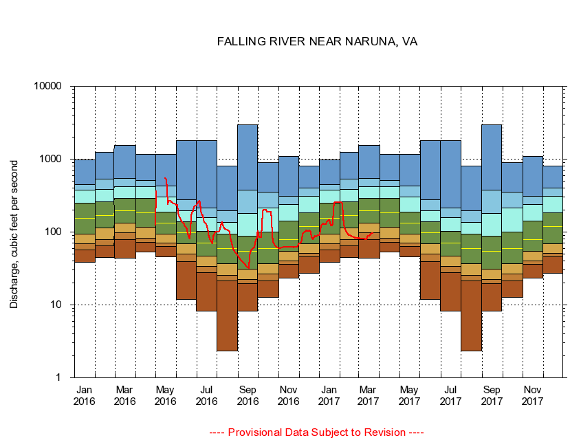
USGS - science for a changing world
Virginia DEQ

Virginia Water Science Center

 
  Duration Plot and Table of 14-Day Average Streamflow
 
02064000 FALLING RIVER NEAR NARUNA, VA
LOCATION.--Latitude 37°07'36", Longitude 78°57'36", North American Datum of 1927,
                    Campbell County, VA, Hydrologic Unit 03010102.
DRAINAGE AREA.--165 square miles.
PERIOD OF RECORD.--July 1929 to January 1935, September 1941 to current year.
DURATION STATISTIC COMPUTATION PERIOD.--All data through September 2015.
REGULATION.--Prior to 1958, diurnal fluctuation caused by mill.
GAGE OPERATION.--Virginia Department of Environmental Quality - Water Division.

     Duration Plot with 14-Day Average Streamflow Conditions
Provisional Data Subject to Revision
02064000 plot. 
FALLING RIVER NEAR NARUNA, VA
Provisional Data Subject to Revision


The current 14-day running-average value for 03/22/2017 is 95.71 cubic feet per second.

  explanation   Percentile Description Duration Plot Description 28 Day 14 Day 7 Day Daily


      Duration Table of 14-Day Average Streamflow
           
Flow values in cubic feet per second


                02064000     FALLING RIVER NEAR NARUNA, VA

   Minimum daily flow
   5th percentile
 
   10th percentile
 
   25th percentile
 
 
   Median
 
 
   75th percentile


   90th percentile


   95th percentile


   Maximum daily flow
         
Years of record
January
38.4
57.2
68.4
92.9
153
248
374
445
989
 
79
February
44.8
65.1
78.5
113
169
260
386
537
1,240
 
79
March
43.6
78.0
96.9
132
194
293
416
545
1,560
 
78
April
52.8
72.1
82.4
116
182
292
419
507
1,160
 
78
May
46.1
63.6
71.4
93.8
132
186
300
425
1,160
 
78
June
11.8
38.9
50.0
69.7
96.9
139
195
278
1,790
 
78
July
8.21
27.9
34.1
46.6
69.9
102
158
212
1,800
 
78
August
2.31
21.4
25.2
36.8
59.0
92.9
136
198
810
 
78
September
8.21
19.6
22.5
30.7
54.4
88.4
179
373
2,990
 
78
October
12.6
21.2
26.7
37.1
59.6
101
213
355
892
 
78
November
23.1
36.4
39.9
54.4
79.4
143
237
307
1,100
 
79
December
27.3
45.4
50.5
69.8
118
182
309
402
813
 
79


The current 14-day running-average value for 03/22/2017 is 95.71 cubic feet per second.

---- Provisional Data Subject to Revision ----

Accessibility FOIA Privacy Policies and Notices

Take Pride in America logo USA.gov logo U.S. Department of the Interior | U.S. Geological Survey
URL: http://va.water.usgs.gov/duration_plots/htm_14/dp02064000.htm
Page Contact Information: Virginia WSC Webmaster
Page Last Modified: 6/19/2016