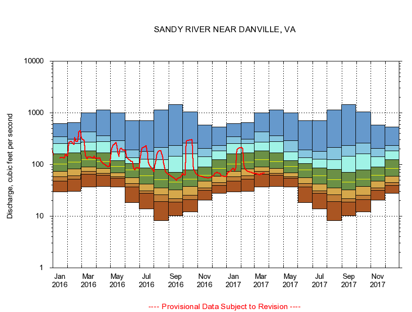
USGS - science for a changing world
Virginia DEQ

Virginia Water Science Center

 
  Duration Plot and Table of 14-Day Average Streamflow
 
02074500 SANDY RIVER NEAR DANVILLE, VA
LOCATION.--Latitude 36°37'10", Longitude 79°30'16", North American Datum of 1927,
                    Pittsylvania County, VA, Hydrologic Unit 03010103
DRAINAGE AREA.--111 square miles.
PERIOD OF RECORD.--October 1929 to current year. Monthly discharge only for some periods, published in WSP 1303.
DURATION STATISTIC COMPUTATION PERIOD.--All data through September 2015.
REGULATION.--Diurnal fluctuation at low flow cause by small mill.
GAGE OPERATION.--Virginia Department of Environmental Quality - Water Division.

     Duration Plot with 14-Day Average Streamflow Conditions
Provisional Data Subject to Revision
02074500 plot. 
SANDY RIVER NEAR DANVILLE, VA
Provisional Data Subject to Revision


The current 14-day running-average value for 03/22/2017 is 68.21 cubic feet per second.

  explanation   Percentile Description Duration Plot Description 28 Day 14 Day 7 Day Daily


      Duration Table of 14-Day Average Streamflow
           
Flow values in cubic feet per second


                02074500     SANDY RIVER NEAR DANVILLE, VA

   Minimum daily flow
   5th percentile
 
   10th percentile
 
   25th percentile
 
 
   Median
 
 
   75th percentile


   90th percentile


   95th percentile


   Maximum daily flow
         
Years of record
January
29.9
47.5
58.5
73.0
102
160
255
344
618
 
86
February
30.4
51.7
60.1
82.6
111
168
253
311
650
 
86
March
37.2
64.1
73.2
90.6
125
185
274
430
1,010
 
86
April
37.4
62.0
67.8
83.9
114
170
275
360
1,150
 
86
May
36.5
54.1
58.3
69.8
92.0
120
175
289
1,010
 
86
June
18.5
37.1
43.2
55.8
78.3
104
137
193
707
 
86
July
13.9
27.7
31.0
42.1
61.1
86.2
128
179
708
 
86
August
8.17
19.0
26.0
35.3
50.9
80.1
125
215
1,130
 
86
September
10.2
18.6
21.7
32.1
46.2
70.6
145
232
1,460
 
86
October
12.1
20.9
25.2
37.9
52.1
78.0
162
261
1,050
 
85
November
20.5
31.6
35.1
47.4
62.4
90.5
141
203
577
 
86
December
27.5
38.9
45.2
59.1
83.6
123
185
231
530
 
86


The current 14-day running-average value for 03/22/2017 is 68.21 cubic feet per second.

---- Provisional Data Subject to Revision ----

Accessibility FOIA Privacy Policies and Notices

Take Pride in America logo USA.gov logo U.S. Department of the Interior | U.S. Geological Survey
URL: http://va.water.usgs.gov/duration_plots/htm_14/dp02074500.htm
Page Contact Information: Virginia WSC Webmaster
Page Last Modified: 6/19/2016