|
03164000
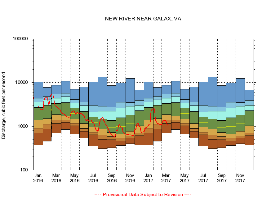
NEW RIVER NEAR GALAX, VA
|
Minimum daily flow
|
|
|
5th percentile
|
|
|
|
10th percentile
|
|
|
|
|
25th percentile
|
|
|
|
|
|
Median
|
|
|
|
|
|
|
75th percentile
|
|
|
|
|
|
|
|
90th percentile
|
|
|
|
|
|
|
|
|
95th percentile
|
|
|
|
|
|
|
|
|
|
Maximum daily flow
|
|
|
|
|
|
|
|
|
|
|
|
Years of record
|
January
|
374
|
692
|
895
|
1,390
|
1,900
|
2,700
|
3,580
|
4,400
|
10,400
|
|
86
|
February
|
453
|
854
|
1,120
|
1,500
|
2,240
|
3,030
|
4,040
|
4,800
|
7,730
|
|
86
|
March
|
709
|
1,150
|
1,400
|
1,840
|
2,470
|
3,310
|
4,380
|
5,490
|
8,670
|
|
86
|
April
|
849
|
1,230
|
1,400
|
1,720
|
2,350
|
3,500
|
4,790
|
5,660
|
10,700
|
|
86
|
May
|
660
|
1,020
|
1,170
|
1,480
|
1,980
|
2,630
|
3,370
|
4,100
|
6,970
|
|
86
|
June
|
543
|
769
|
894
|
1,160
|
1,550
|
2,190
|
2,970
|
3,600
|
7,920
|
|
86
|
July
|
356
|
640
|
735
|
962
|
1,210
|
1,620
|
2,120
|
3,020
|
10,400
|
|
86
|
August
|
309
|
498
|
627
|
858
|
1,080
|
1,460
|
2,220
|
2,880
|
13,400
|
|
86
|
September
|
322
|
494
|
584
|
718
|
949
|
1,350
|
2,200
|
2,780
|
8,600
|
|
86
|
October
|
365
|
465
|
532
|
677
|
1,000
|
1,580
|
2,650
|
3,530
|
9,720
|
|
85
|
November
|
401
|
548
|
603
|
771
|
1,180
|
1,830
|
2,880
|
3,490
|
12,400
|
|
86
|
December
|
374
|
615
|
692
|
1,030
|
1,540
|
2,290
|
3,020
|
3,890
|
6,640
|
|
86
|
|
|
|