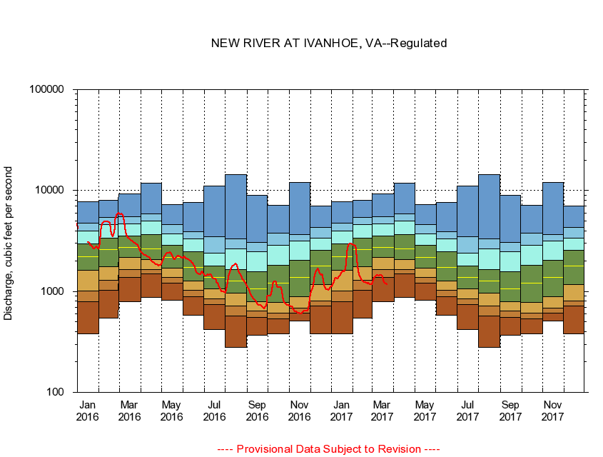
USGS - science for a changing world
Virginia DEQ

Virginia Water Science Center

 
  Duration Plot and Table of 14-Day Average Streamflow
 
03165500 NEW RIVER AT IVANHOE, VA
LOCATION.--Latitude 36°50'05", Longitude 80°57'10", North American Datum of 1927,
                    Wythe County, VA, Hydrologic Unit 05050001.
DRAINAGE AREA.--1,350 square miles.
PERIOD OF RECORD.--August to December 1927, October 1929 to September 1978, February 1996 to current year. Monthly discharge only for some periods, published in WSP 1305. Gage-height records collected in vicinity, October 1916 to July 1943, are contained in reports of the National Weather Service.
DURATION STATISTIC COMPUTATION PERIOD.--All data through September 2007.
REGULATION.--Flow regulated by powerplants about 2.8 and 5.5 miles upstream.
GAGE OPERATION.--U.S. Geological Survey, Virginia Water Science Center.

     Duration Plot with 14-Day Average Streamflow Conditions
Provisional Data Subject to Revision
03165500 plot. 
NEW RIVER AT IVANHOE, VA
Provisional Data Subject to Revision


The current 14-day running-average value for 10/14/2008 is 950.07 cubic feet per second.

  explanation   Percentile Description Duration Plot Description 28 Day 14 Day 7 Day Daily


      Duration Table of 14-Day Average Streamflow
           
Flow values in cubic feet per second


                03165500     NEW RIVER AT IVANHOE, VA

   Minimum daily flow
   5th percentile
 
   10th percentile
 
   25th percentile
 
 
   Median
 
 
   75th percentile


   90th percentile


   95th percentile


   Maximum daily flow
         
Years of record
January
379
771
949
1,630
2,210
2,960
3,910
4,670
7,810
 
60
February
540
990
1,300
1,850
2,640
3,460
4,600
5,260
7,940
 
61
March
793
1,350
1,610
2,160
2,760
3,630
4,650
5,480
9,310
 
61
April
870
1,470
1,610
2,050
2,670
3,730
4,980
5,940
11,900
 
61
May
816
1,180
1,340
1,680
2,140
2,800
3,630
4,380
6,800
 
61
June
580
900
1,020
1,270
1,740
2,470
3,230
3,820
7,600
 
61
July
417
735
849
1,080
1,410
1,830
2,360
3,300
7,020
 
61
August
341
584
727
974
1,310
1,700
2,580
3,090
14,300
 
61
September
370
541
631
784
1,060
1,530
2,520
3,120
8,960
 
62
October
415
548
614
770
1,200
1,860
2,940
3,960
7,150
 
60
November
510
606
657
892
1,450
2,100
3,230
3,750
12,100
 
61
December
379
717
807
1,170
1,760
2,530
3,260
4,270
7,020
 
61


The current 14-day running-average value for 10/14/2008 is 950.07 cubic feet per second.

---- Provisional Data Subject to Revision ----

Accessibility FOIA Privacy Policies and Notices

Take Pride in America logo USA.gov logo U.S. Department of the Interior | U.S. Geological Survey
URL: http://va.water.usgs.gov/duration_plots/htm_14/dp03165500.htm
Page Contact Information: Virginia WSC Webmaster
Page Last Modified: 9/19/2008