|
03170000
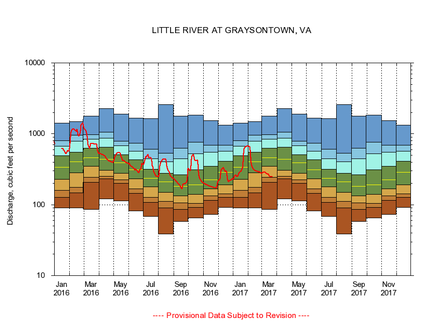
LITTLE RIVER AT GRAYSONTOWN, VA
|
Minimum daily flow
|
|
|
5th percentile
|
|
|
|
10th percentile
|
|
|
|
|
25th percentile
|
|
|
|
|
|
Median
|
|
|
|
|
|
|
75th percentile
|
|
|
|
|
|
|
|
90th percentile
|
|
|
|
|
|
|
|
|
95th percentile
|
|
|
|
|
|
|
|
|
|
Maximum daily flow
|
|
|
|
|
|
|
|
|
|
|
|
Years of record
|
January
|
90.4
|
127
|
160
|
230
|
337
|
490
|
674
|
799
|
1,420
|
|
87
|
February
|
89.8
|
148
|
176
|
280
|
406
|
554
|
783
|
958
|
1,490
|
|
87
|
March
|
85.3
|
206
|
243
|
348
|
461
|
626
|
842
|
980
|
1,780
|
|
87
|
April
|
121
|
232
|
252
|
306
|
441
|
648
|
874
|
1,060
|
2,280
|
|
87
|
May
|
113
|
199
|
223
|
276
|
390
|
508
|
678
|
788
|
1,900
|
|
87
|
June
|
82.0
|
145
|
167
|
231
|
313
|
432
|
571
|
735
|
1,670
|
|
87
|
July
|
67.9
|
108
|
127
|
178
|
237
|
314
|
448
|
609
|
1,650
|
|
87
|
August
|
38.5
|
89.9
|
112
|
150
|
212
|
278
|
401
|
534
|
2,570
|
|
87
|
September
|
58.4
|
86.5
|
107
|
134
|
182
|
264
|
448
|
628
|
1,770
|
|
87
|
October
|
65.5
|
92.4
|
104
|
141
|
192
|
309
|
527
|
757
|
1,840
|
|
86
|
November
|
72.4
|
116
|
133
|
168
|
226
|
346
|
550
|
691
|
1,530
|
|
87
|
December
|
91.1
|
128
|
142
|
190
|
287
|
413
|
573
|
694
|
1,320
|
|
87
|
|
|
|