|
03208500
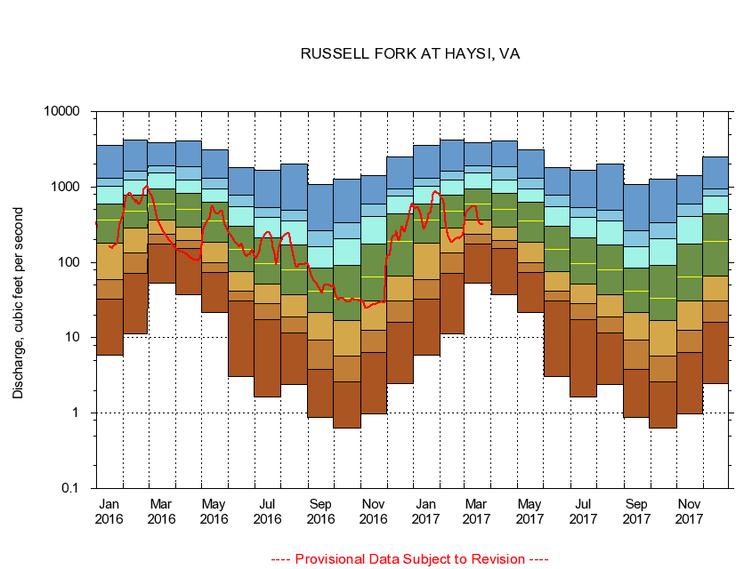
RUSSELL FORK AT HAYSI, VA
|
Minimum daily flow
|
|
|
5th percentile
|
|
|
|
10th percentile
|
|
|
|
|
25th percentile
|
|
|
|
|
|
Median
|
|
|
|
|
|
|
75th percentile
|
|
|
|
|
|
|
|
90th percentile
|
|
|
|
|
|
|
|
|
95th percentile
|
|
|
|
|
|
|
|
|
|
Maximum daily flow
|
|
|
|
|
|
|
|
|
|
|
|
Years of record
|
January
|
5.89
|
32.7
|
59.6
|
181
|
361
|
600
|
1,030
|
1,300
|
3,520
|
|
89
|
February
|
11.3
|
72.2
|
133
|
285
|
484
|
783
|
1,240
|
1,610
|
4,220
|
|
89
|
March
|
52.9
|
175
|
233
|
364
|
589
|
935
|
1,550
|
1,930
|
3,820
|
|
89
|
April
|
37.0
|
151
|
193
|
295
|
503
|
819
|
1,220
|
1,860
|
4,030
|
|
89
|
May
|
21.4
|
73.8
|
99.6
|
186
|
354
|
634
|
952
|
1,320
|
3,090
|
|
89
|
June
|
3.03
|
30.6
|
41.3
|
75.4
|
147
|
300
|
548
|
781
|
1,820
|
|
89
|
July
|
1.64
|
17.4
|
28.6
|
51.5
|
96.9
|
214
|
393
|
526
|
1,650
|
|
89
|
August
|
2.43
|
11.7
|
19.1
|
37.5
|
79.4
|
171
|
350
|
486
|
2,020
|
|
90
|
September
|
0.87
|
3.84
|
9.39
|
21.8
|
41.9
|
83.7
|
163
|
264
|
1,090
|
|
90
|
October
|
0.63
|
2.57
|
5.67
|
17.0
|
33.4
|
91.6
|
204
|
339
|
1,280
|
|
89
|
November
|
0.98
|
6.38
|
12.7
|
30.4
|
64.6
|
174
|
403
|
586
|
1,430
|
|
89
|
December
|
2.46
|
16.2
|
30.5
|
65.9
|
192
|
436
|
751
|
939
|
2,500
|
|
89
|
|
|
|