|
03473000
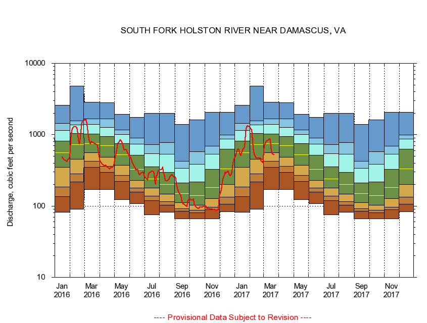
SOUTH FORK HOLSTON RIVER NEAR DAMASCUS, VA
|
Minimum daily flow
|
|
|
5th percentile
|
|
|
|
10th percentile
|
|
|
|
|
25th percentile
|
|
|
|
|
|
Median
|
|
|
|
|
|
|
75th percentile
|
|
|
|
|
|
|
|
90th percentile
|
|
|
|
|
|
|
|
|
95th percentile
|
|
|
|
|
|
|
|
|
|
Maximum daily flow
|
|
|
|
|
|
|
|
|
|
|
|
Years of record
|
January
|
81.3
|
135
|
185
|
346
|
557
|
810
|
1,140
|
1,440
|
2,570
|
|
84
|
February
|
90.3
|
216
|
284
|
452
|
720
|
1,040
|
1,360
|
1,560
|
4,830
|
|
84
|
March
|
171
|
350
|
421
|
563
|
750
|
1,020
|
1,400
|
1,670
|
2,840
|
|
84
|
April
|
170
|
294
|
362
|
481
|
697
|
946
|
1,260
|
1,670
|
2,800
|
|
84
|
May
|
122
|
222
|
270
|
373
|
528
|
752
|
1,010
|
1,170
|
1,930
|
|
84
|
June
|
108
|
156
|
180
|
227
|
325
|
517
|
737
|
895
|
1,740
|
|
84
|
July
|
75.4
|
119
|
137
|
179
|
239
|
357
|
545
|
730
|
1,980
|
|
84
|
August
|
82.4
|
103
|
115
|
146
|
202
|
298
|
534
|
780
|
1,990
|
|
84
|
September
|
65.9
|
84.9
|
92.1
|
111
|
149
|
209
|
336
|
423
|
1,390
|
|
84
|
October
|
65.8
|
80.3
|
87.6
|
103
|
139
|
216
|
385
|
579
|
1,600
|
|
83
|
November
|
66.5
|
88.5
|
96.9
|
126
|
183
|
329
|
533
|
691
|
2,050
|
|
84
|
December
|
83.2
|
107
|
133
|
200
|
332
|
627
|
871
|
988
|
2,060
|
|
84
|
|
|
|