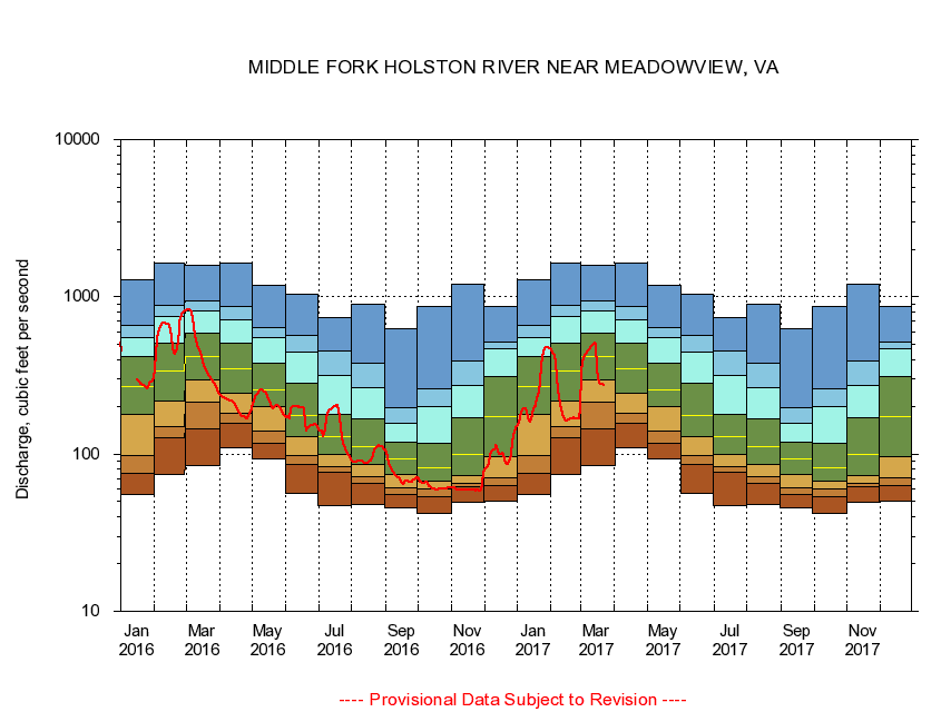
USGS - science for a changing world
Virginia DEQ

Virginia Water Science Center

 
  Duration Plot and Table of 14-Day Average Streamflow
 
03475000 MIDDLE FORK HOLSTON RIVER NEAR MEADOWVIEW, VA
LOCATION.--Latitude 36°42'47", Longitude 81°49'08", North American Datum of 1927,
                    Washington County, VA, Hydrologic Unit 06010102.
DRAINAGE AREA.--206 square miles.
PERIOD OF RECORD.--October 1931 to September 1953, May 1976 to current year. Monthly discharge only for October 1931, published in WSP 1306.
DURATION STATISTIC COMPUTATION PERIOD.--May 1976 through September 2015.
REGULATION.--Flow regulated by powerplant about 0.9 mile above gage prior to 1954.
GAGE OPERATION.--U.S. Geological Survey, Virginia Water Science Center.

     Duration Plot with 14-Day Average Streamflow Conditions
Provisional Data Subject to Revision
03475000 plot. 
MIDDLE FORK HOLSTON RIVER NEAR MEADOWVIEW, VA
Provisional Data Subject to Revision


The current 14-day running-average value for 03/22/2017 is 274.64 cubic feet per second.

  explanation   Percentile Description Duration Plot Description 28 Day 14 Day 7 Day Daily


      Duration Table of 14-Day Average Streamflow
           
Flow values in cubic feet per second


                03475000     MIDDLE FORK HOLSTON RIVER NEAR MEADOWVIEW, VA

   Minimum daily flow
   5th percentile
 
   10th percentile
 
   25th percentile
 
 
   Median
 
 
   75th percentile


   90th percentile


   95th percentile


   Maximum daily flow
         
Years of record
January
54.9
75.4
98.4
180
267
418
548
655
1,280
 
39
February
74.1
126
150
218
338
510
746
882
1,630
 
39
March
84.4
145
215
296
418
591
809
939
1,590
 
39
April
109
157
181
242
346
510
718
868
1,630
 
39
May
92.6
117
139
200
254
378
553
632
1,180
 
39
June
55.8
85.6
97.8
129
175
280
444
565
1,040
 
40
July
46.7
76.1
82.5
98.7
130
180
318
452
740
 
40
August
48.0
65.1
71.7
85.7
112
168
263
381
895
 
40
September
45.8
55.6
61.5
73.6
92.8
119
158
198
622
 
40
October
42.1
53.3
60.1
67.3
81.7
118
200
259
875
 
39
November
49.4
61.8
65.6
72.6
99.1
170
271
393
1,200
 
39
December
50.5
63.1
70.4
95.6
174
311
465
516
873
 
39


The current 14-day running-average value for 03/22/2017 is 274.64 cubic feet per second.

---- Provisional Data Subject to Revision ----

Accessibility FOIA Privacy Policies and Notices

Take Pride in America logo USA.gov logo U.S. Department of the Interior | U.S. Geological Survey
URL: http://va.water.usgs.gov/duration_plots/htm_14/dp03475000.htm
Page Contact Information: Virginia WSC Webmaster
Page Last Modified: 6/19/2016